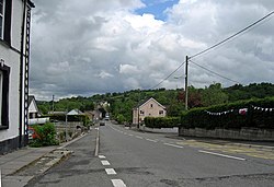
Pencader
| Pencader | |
| Carmarthenshire | |
|---|---|

| |
| Location | |
| Grid reference: | SN445359 |
| Location: | 52°0’4"N, 4°15’58"W |
| Data | |
| Population: | 336 (2011[1]) |
| Post town: | Pencader |
| Postcode: | SA39 |
| Dialling code: | 01559 |
| Local Government | |
| Council: | Carmarthenshire |
| Parliamentary constituency: |
Carmarthen East and Dinefwr |
| Website: | http://www.pencader.org.uk/ |
Pencader is a small village in Carmarthenshire, forming part of the parish of Llanfihangel-ar-Arth.[2] It is located around three miles south-east of Llandysul and six miles south-west of Llanybydder.
It is a quiet village set in a valley with little more than 500 houses two shops and two pubs. Pencader's history goes back a long way. For many years it was one of the main stops on the Carmarthen - Aberystwyth rail route, and was the junction for the service to Newcastle Emlyn. The decline of the railways saw the Newcastle Emlyn branch line closed in 1952 and the main line closed to passengers in 1965.
History
A battle was fought here between Gruffydd ap Llywelyn and Hywel ab Edwin in 1041, Gruffydd was the victor and went on to become the first and last King of Wales.
Pencader hosts the site of an old castle, which was probably erected by Gilbert de Clare, 1st Earl of Pembroke in 1145.[3]
Railway village
The broad gauge Carmarthen and Cardigan Railway connected Pencader to both the Great Western Railway, and north to Newcastle Emlyn.
From 1845, a scheme was proposed to connect the industrialised north-west of England and Manchester to the deep water port at Milford Haven, to provide an alternative to the congested Port of Liverpool. Given Parliamentary approval in 1865 as a standard gauge railway, the Manchester and Milford Railway formed a junction with the C&CR at Pencader, and then drove north to Strata Florida, and onwards to the coast at Aberystwyth. Having constructed and made operational the easy section from Pencader to Aberystwyth, the M&MR ran out of money building the connection from Llanidloes to Strata Florida, leaving the mile and a half stub of the Llangurig branch from the Mid-Wales Railway. After being operated by the Cambrian Railways from the 1890s, the M&MR was absorbed into the GWR in 1911.
Under the Beeching Axe of British Railways, in 1965 passenger services to Pencader ceased, with freight and goods ceasing in 1973. The station has been demolished and the site is now used by as a lorry haulage depot.
Image gallery
-
War memorial in Pencader
-
View towards Pencader
-
Horse grazing near the Pencader wind turbine
References
- ↑ Office for National Statistics, Census 2011, Pencader
- ↑ "Town and Community Clerks". Carmarthenshire County Council. 4 January 2011. http://www.carmarthenshire.gov.uk/english/council/councillors/pages/townandcommunityclerks.aspx. Retrieved 13 January 2011.
- ↑ Adrian Pettifer (2009). "Pencader Castle". Welsh Castles. castlewales.com. http://www.castlewales.com/pencader.html. Retrieved 10 June 2010.
Outside links
| ("Wikimedia Commons" has material about Carmarthenshire Pencader) |


