Erskine
| Erskine | |
| Renfrewshire | |
|---|---|
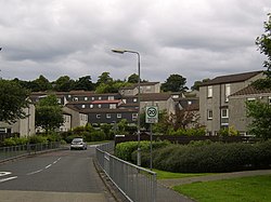
 Park Mains | |
| Location | |
| Grid reference: | NS460667 |
| Location: | 55°54’2"N, 4°27’44"W |
| Data | |
| Population: | 15,347 (2011) |
| Post town: | Erskine |
| Postcode: | PA8 |
| Dialling code: | 0141 |
| Local Government | |
| Council: | Renfrewshire |
| Parliamentary constituency: |
Paisley and Renfrewshire North |
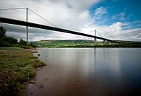
Erskine is a town in Renfrewshire, on the southern bank of the River Clyde. The bridge here provides the lowest crossing point of the river - the Erskine Bridge connects Erskine on the south bank with Old Kilpatrick in Dunbartonshire on the north.
Erskine is a commuter town at the western extent of the Glasgow conurbation, bordering Bishopton to the north and Renfrew, Inchinnan, Paisley and Glasgow Airport to the south.
Originally a small village settlement, Erskine has expanded since the 1970s as a new town, boosting the population to over 15,000. In 2014, it was rated one of the most attractive postcode areas to live in Scotland. [1]
History

The name "Erskine" derives from the Scottish Gaelic phrase "Ard Sescenn", meaning "High Marsh". The first recorded mention of Erskine is at the confirmation of the church of Erskine in 1207 by Florentius, Bishop of Glasgow.[2]
The land around the town was first part of the estate of Henry de Erskine in the 13th century. Sir John Hamilton of Orbiston held the estate in the 17th century until 1703 when it was acquired by the Lords Blantyre.[3] By 1782 there were twelve houses and a church in Erskine. A new church was then built which is still in use today.
An influx of workmen moved to the area during 1836-41 due to the construction of the Inverclyde railway line. In 1900 the estate passed into the ownership of William Arthur Baird, who inherited it from his grandfather, Charles Stuart, 12th Lord Blantyre.[2]
In the late 18th century, the town of Erskine was a hamlet. During this time, stone quays were constructed to support the Erskine Ferry to Old Kilpatrick and Dunbartonshire. This replaced the river ford which had been in place since the Middle Ages. In light of increased industry and infrastructure in the surrounding area, it gradually became a village in the following century. The small church community grew to having 3,000 residents in 1961, when the council unveiled its "New Community" plan for the town's development.[3]
The development began in 1971 with the building of both privately owned and rented accommodation which boosted the town's population by around 10,000. Having established itself as a thriving commuter town, the 1990s saw the building of larger and more expensive housing, aimed at more affluent property buyers. Due to apprehension about further expansion of the town, several proposals for further large housing developments have been rejected. This is largely because the town has only one secondary school.
Geography
The town expanded in the 1970s with the construction of housing association stock. Since that decade, considerable private housing developments have continued. As more private houses were built in the 1980s, Erskine started to become an attractive place to live due to location factors and accessibility to main roads and the M8 motorway. Due to this there was a major boom in property development in the 80s and 90s. Most ex-and existing housing association stock are found in the Bargarran, North Barr and Park Mains areas of the town. Private housing is mostly found in the west part of the town, e.g. Garnieland, Flures Drive, Hawthorn, Parkvale, Parkinch, St. Annes, West Freelands. Many house builders that have been attracted to the area include Miller Homes, Avonside, L & C, Beazer, Cala, Kier and Tay Homes.
Economy

The town's Bridgewater complex provides a range of tertiary sector businesses, chiefly retail and leisure facilities. These include a Morrisons and Aldis supermarket, a tanning salon, a dental surgery, a Greggs bakery, a butcher, a fish & chip shop, a Subway store, a pub with dining area, a Chinese restaurant, an optician, a chemist, a doctors surgery, hardware store, Ladbrokes bookmakers, a hair salon, an estate agency, a dry-cleaners and key cutting service, a swimming pool, a funeral directors, a bank and a public library. There are also smaller retail areas in the Bargarran, Mains Drive and Park Glade areas, where there are a few shops and restaurants as well as a community centre.
On the riverside, there are two office blocks. A call centre is based in one and a logistics company in the other. The Erskine Bridge Hotel (formerly Esso Motor Hotel) is also situated on the banks of the Clyde.[4]
Sport
There is two private golf clubs in Erskine:
- The Erskine Golf Club is located on the border between Erskine and Bishopton.[5]
- The Mar Hall Hotel and Golf Course is less than a mile away.[6]
In addition to a number of local playing fields, the area has two recently constructed sporting facilities: the Erskine Community Sports Centre and the Astroturf at Park Mains High School.
Erskine Bridge

- Main article: Erskine Bridge
The Erskine Bridge towers high over the western limit of the town. The bridge is the furthest west crossing point on the river and it soon expands to become the Firth of Clyde estuary.[7]
About the town
Erskine House

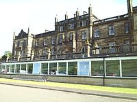
Erskine House was constructed between 1828–45. It was designed by Sir Robert Smirke, the architect of the British Museum.[8] During the First World War it became the Princess Louise Scottish Hospital for Limbless Sailors and Soldiers.[9]
It is now the 5-star Mar Hall Hotel, recalling the estate’s former ownership by the Earl of Mar.[10]
Erskine Hospital

The Erskine Hospital is a facility that provides long-term care for veterans of the British Armed Forces. The charity opened as Princess Louise Scottish Hospital for Limbless Sailors and Soldiers in 1916 due to the urgent need to treat the thousands of military personnel that lost their limbs in the First World War. It has gone on to offer help to British ex-servicemen from all wars since the First World War.
The charity is close celebrated its centenary year in 2016 and it has grown to become the biggest ex-services facility in the country.
The charity has three units within the Erskine area and also specialist units in Glasgow and Edinburgh. The charity has strong links with the British Royal Family. Prince Charles is the charity's patron. He opened the flagship unit called Erskine Home in 2000. Princess Anne has also opened various units for the charity.
The charity holds various fundraising schemes throughout the year. They host an annual motorbike meet, a classic car show and an annual dog show. Within the hospital grounds there is a garden centre where profits go to the charity. There is an annual Erskine Week. The fundraising event is to celebrate the official opening of the hospital in 1916.
Boden Boo

There is a woodland area beneath the Erskine Bridge with about two miles of informal trails, picnic areas and views of the River Clyde. The area is ideal for walking and cycling. The Erskine Beach is here too. The Forestry Commission are responsible for the area.[11][12]
Newshot Island
Newshot Island provides a rare natural habitat, formalised as the Newshot Island Nature Reserve. The resercve is a salt marsh which juts out into the River Clyde. Though named "island", the site is now a peninsula, created from silt left over from the widening and deepening of the river in the 1930s, which connected the island to Erskine.
The nature reserve acts as a feeding and resting point for a wide array of migratory birds traveling to and from regions such as North America, Siberia and West Africa.[13]
Pictures
-
A sign commemorating the first completed block of housing in Erskine
-
Torran Drive
-
North Barr
-
Erskine Bridge Hotel
-
Mainshill Gardens
-
St. Bernadette's Church
-
Mainscroft
Outside links
| ("Wikimedia Commons" has material about Erskine) |
References
- ↑ "UK's 'most desirable' postcodes revealed". BBC News. http://www.bbc.co.uk/news/business-28918709.
- ↑ 2.0 2.1 Anderson, John Fyfe (2009). Old Bishopton, Erskine and Langbank. Catrine, Ayrshire: Stenlake Publishing. p. 3. ISBN 9781840334791. http://www.stenlake.co.uk/books/view_book.php?ref=600.
- ↑ 3.0 3.1 "Overview of Erskine". Scottish-places.info. http://www.scottish-places.info/towns/townfirst376.html. Retrieved 2014-02-06.
- ↑ The Erskine Bridge Hotel
- ↑ Erskine Golf Club and Golf Course
- ↑ Luxury 5 Star Hotel Glasgow
- ↑ "Welcome to the Erskine Bridge!". Erskinebridge.co.uk. http://www.erskinebridge.co.uk/. Retrieved 2014-06-17.
- ↑ "History of Erskine House: Former World War 1 hospital, now 5-star Mar Hall Hotel - Clyde Waterfront Heritage". Clydewaterfrontheritage.com. http://www.clydewaterfrontheritage.com/erskinehouse.aspx. Retrieved 2014-02-06.
- ↑ "The history of Erskine". Rememberingscotlandatwar.org.uk. http://www.rememberingscotlandatwar.org.uk/Accessible/Exhibition/170/The-history-of-Erskine. Retrieved 2014-02-06.
- ↑ "Luxury 5 Star Hotel Glasgow – Scottish Golf & Spa Resort". Mar Hall. http://www.marhall.com/. Retrieved 2014-06-17.
- ↑ "Boden Boo - Forestry Commission Scotland". Scotland.forestry.gov.uk. http://scotland.forestry.gov.uk/visit/boden-boo. Retrieved 2014-06-17.
- ↑ "Boden Boo Community Woodland, Erskine: plans to improve woodland - Green Network". Clydewaterfront.com. http://www.clydewaterfront.com/projects/clydebank--erskine/public-amenity/e138---boden-boo. Retrieved 2014-06-17.
- ↑ "Newshot Island" (PDF). Renfrewshire Council. http://www.renfrewshire.gov.uk/wps/wcm/connect/7ca1702a-b9a6-4f4a-a546-8ba6398578dd/pt-as-ErskineandTheClyde.pdf?MOD=AJPERES&CACHEID=7ca1702a-b9a6-4f4a-a546-8ba6398578dd.


