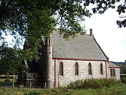
Struy
| Struy Gaelic: An t-Srùigh | |
| Inverness-shire | |
|---|---|
 Struy Church | |
| Location | |
| Grid reference: | NH401403 |
| Location: | 57°25’30"N, 4°39’50"W |
| Data | |
| Post town: | Beauly |
| Postcode: | IV4 |
| Dialling code: | 01463 |
| Local Government | |
| Council: | Highland |
| Parliamentary constituency: |
Ross, Skye and Lochaber |
Struy is a small village in the parish of Kilmorack, Inverness-shire about ten miles south-west of Beauly.
The confluence of the River Farrar and the River Glass is a short distance to the east of Struy — here the rivers join to become the River Beauly. The River Farrar is crossed by Struy Bridge a short distance to the north, carrying the A831 road. A minor road crosses the Mauld Bridge, over the River Glass, to the south-east of Struy.
Erchless Castle lies about a mile north-east of Struy.
References
This Inverness-shire article is a stub: help to improve Wikishire by building it up.