Forgandenny
| Forgandenny | |
| Perthshire | |
|---|---|
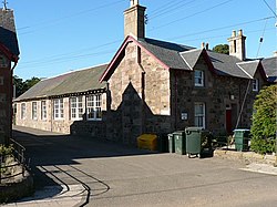
 The school in Forgandenny | |
| Location | |
| Grid reference: | NO087182 |
| Location: | 56°20’52"N, 3°28’40"W |
| Data | |
| Postcode: | PH2 |
| Local Government | |
| Council: | Perth and Kinross |
Forgandenny is a small village in Perthshire, found just west of Bridge of Earn (whose unenviable location is in a loop in the M90 motorway). The River Earn flows to the north, the other side of the railway line, and becomes tidal just below Forgandenny before entering the River Tay beyond Bridge of Earn.
The village sits four miles south of the county town, Perth. Perth is a 20 minute bus ride from Forgandenny. The village is also close to the East Coast Main Line.
Forgandenny has a church (of Norman origin, though the windows and doors are not original), village hall, a primary school and a Bed and Breakfast. Near the village since 1920 is Strathallan School, a boarding school of approximately 550 pupils and 70 staff, many of whom live in Forgandenny.
Gregory Ross released a book called "Forgandenny, a Place in History" on the December 1, 2007. The book tells the story of the history of Forgandenny and also includes Aberdalgie, Pathstruie, West Dron and Pitkeathly
Outside links
| ("Wikimedia Commons" has material about Forgandenny) |
- Forgandenny, a Place in History by Gregory Ross
- Excerpt from the 1861 parochial directory for Fife and Kinross: Forgandenny
- Kinross, Scotland: 1841 Census of the Parish of Forgandenny
- Forgandenny, Perth and Kinross The Gazetteer for Scotland
