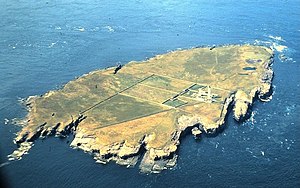
Muckle Skerry

Muckle Skerry is the largest of the Pentland Skerries that lie at the eastern end of the Pentland Firth between Caithness and Orkney, and belonging to the latter. Here stands the Pentland Skerries Lighthouse.
Many shipwrecks have occurred around the skerries.
Muckle Skerry is the westernmost of the Pentland Skerries. At three-fifths of a mile long and rising to a height of 66 feet above sea level, it is big enough to be considered an island. However the notoriously fierce tides and stormy weather of the firth have rendered Muckle Skerry uninhabitable and as such it is more often thought of as a skerry.
Notwithstanding the bleak location however, there are signs of past habitation on Muckle Skerry: apart form the lighthouse, the island has tumuli, the remains of a chapel and even a possible broch.[1]
Lighthouse

and his stepson by Robert Stevenson: this was the first light that Stevenson officially worked on, but the first of many. It was also only the fifth modern lighthouse built in Scotland.
Outside links
| ("Wikimedia Commons" has material about Muckle Skerry) |
- Location map: 58°41’18"N, 2°55’35"W
- Map: ND464782
- Northern Lighthouse Board - Pentland Skerries
- RCAHMS record - Muckle Skerry Old Lighthouse
