Zouch
| Zouch | |
| Nottinghamshire | |
|---|---|
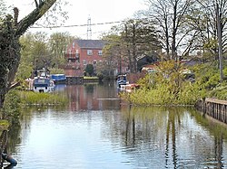
 The Soar at Zouch | |
| Location | |
| Grid reference: | SK507234 |
| Location: | 52°48’23"N, 1°14’59"W |
| Data | |
| Post town: | Loughborough |
| Postcode: | LE12 |
| Dialling code: | 01509 |
| Local Government | |
| Council: | Rushcliffe |
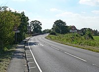
Zouch (pron. ˈzɒtʃ) is a tiny village of Nottinghamshire within the parish of Sutton Bonington. It is stands on the north bank of the River Soar which marks the county boundary with Leicestershire, constricted in the small space between the Soar and the navigation canal; the Zouch Cut. Zouch is on the A6006 road, which crosses the Soar here on the Zouch Bridge.
There is in the hamlet a single pub (the Rose and Crown).
To the east is Normanton on Soar in Nottinghamshire and to the south Hathern in Leicestershire.
The village is named after the Zouche family.

River and canal
Zouch is an example of a small canal settlement, though there was a mill there long before the Soar was made navigable (and on some historic maps is denoted as Zouch Mill). The canalisation of the River Soar, involving the construction of the Zouch Cut and several weirs and canals in the vicinity, left the hamlet on an island. A series of islands lie within the main course of the river, but Zouch's is created by the canal. Canal boats moor here frequently.