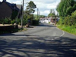
Dalton, Dumfriesshire
| Dalton | |
| Dumfriesshire | |
|---|---|
 Dalton | |
| Location | |
| Grid reference: | NY113732 |
| Location: | 55°2’46"N, 3°23’18"W |
| Data | |
| Postcode: | DG11 |
| Local Government | |
| Council: | Dumfries and Galloway |
| Parliamentary constituency: |
Dumfries and Galloway |
Dalton is a small village in Dumfriesshire, in Annandale about 10 miles southeast of Dumfries and 4 miles south of Lockerbie. It is on the B7020 Annan to Lochmaben road.
The village is about a mile to the west and to the south of the meanders of the River Annan. The Dalton Burn, a little stream, runs through the village and north to the main river. The name of the village, a common name across Great Britain, is apparently from the Old English for 'Dale Village', appropriately.
Dalton has a pub, a restaurant and a well used village hall.
Parish kirk

The village has an 18th-century church, one of its past ministers being The Rev. John W. Morris MA, who is buried near the southern boundary of the church.
Several local families are well represented in the kirkyard; the Byers, Bells, Shuttleworths, Carruthers,[1] Murrays, and Steels.
About the village
About a mile west of Dalton on the Carrutherstown road is Dalton Pottery.[2] On the farms around Dalton, there are several self-catering, stone-built, holiday cottages at Kirkwood.
It is visited for its peace, and fine fishing on the River Annan.
| ("Wikimedia Commons" has material about Dalton, Dumfriesshire) |
