Powerstock
| Powerstock | |
| Dorset | |
|---|---|
 Powerstock | |
| Location | |
| Grid reference: | SY517962 |
| Location: | 50°45’49"N, 2°41’11"W |
| Data | |
| Population: | 320 (2012 est.) |
| Post town: | Bridport |
| Local Government | |
| Council: | Dorset |
| Parliamentary constituency: |
West Dorset |
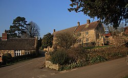
Powerstock is a village in south-western Dorset, lying in a steep valley on the edge of the Dorset Downs, five miles northeast of Bridport. The civil parish includes the village of West Milton to the west and the summit and northern slopes of Eggardon Hill to the south-east.
Powerstock village is a pretty place, though small. It contains many cottages and two inns: The Three Horseshoes near the church and The Marquis of Lorne Inn on the other side of the valley in a small hamlet called Nettlecombe. The Mangerton River runs through the valley
Name
The origins of the name Powerstock have not been fully determined; the second part derives from the Old English stoc, indicating an outlying farmstead, but the first part is unresolved.[1] It may be of the same original as the name of nearby Poorton.
In the Domesday Book of 1086 it was recorded as Povrestoch.[1] According to one source, the name was 'Poorstock' until the Bridport Railway was built through the village in 1857, when the change to Powerstock was made (so, it is said, to avoid connotations of 'poor (rolling) stock').[2] However another source states the name existed in its current form as early as 1787.[3]
Powerstock railway station (and the entire Bridport branch line) closed on 5 May 1975.
About the village
Poorstock Forest was one of the 80 royal forests created by the Normans in the 11th, 12th and early 13th centuries, as hunting reserves.
The nearby Eggardon Hill, 827 feet, stands a mile and a half southeast of the village. On the summit is an Iron Age hill fort covering 35 acres, from which can be viewed a wide panorama of the west Dorset countryside.
Just over a mile to the east of the village is Powerstock Common, a nature reserve.
Another prominent hill is Drackenorth, some two miles to the north which lies on the Jubilee Trail.
On film
Powerstock was used as the filming location for the BBC productions of Agatha Christie's "A Murder is Announced" and the 2010 Springwatch series.

Outside links
| ("Wikimedia Commons" has material about Powerstock) |
References
- ↑ 1.0 1.1 David Mills, ed (2011). "A Dictionary of British Place-Names". Oxford University Press. p. 375. http://books.google.co.uk/books?id=tXucAQAAQBAJ&pg=PA375&lpg=PA375&dq=powerstock+dictionary+place+names&source=bl&ots=D1id59zryP&sig=TYgOycjYwFg5QTinWt-2GCwAyQE&hl=e. Retrieved 15 May 2014.
- ↑ Diana P Read Powerstock Station All Change. ISBN 0-9527522-0-4
- ↑ Matt Wilkinson (January 2014). "The Dorset drive: The valleys of the West and the scenic coast road". Dorset Life Magazine. http://www.dorsetlife.co.uk/2014/01/the-dorset-drive-the-valleys-of-the-west-and-the-scenic-coast-road/. Retrieved 15 May 2014.
