Garmouth
| Garmouth Gaelic: Geàrr Magh Scots: Germouth, Gairmou′ | |
| Morayshire | |
|---|---|
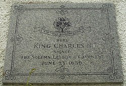
 King Charles II plaque | |
| Location | |
| Location: | 57°39’48"N, 3°6’33"W |
| Data | |
| Post town: | Fochabers |
| Postcode: | IV32 |
| Dialling code: | 01343 |
| Local Government | |
| Council: | Moray |
| Parliamentary constituency: |
Moray |
Garmouth is a village in north-east Morayshire adjacent to the River Spey which here forms the border with Banffshire. The village lies close to the mouth of the Spey and the coast of the Moray Firth at nearby Kingston-on-Spey (originally called the Port of Garmouth, it was renamed after a number of shipbuilders from Kingston-upon-Hull found success there).
Garmouth has a claim to fame as the landing point of King Charles II on his return from exile in AD 1650. A plaque in the village commemorates his signing there of the 1638 National Covenant and the 1643 Solemn League and Covenant shortly after coming ashore.
The village is also home to the Maggie Fair (originally a slave market), a historical annual event which in modern times takes the form of stalls for all ages. There is talk that in 2009 live music will become a much more prominent part of Maggie Fair, with ceilidhs featuring local young bands.
Notes
| ("Wikimedia Commons" has material about Garmouth) |

This Morayshire article is a stub: help to improve Wikishire by building it up.
