Burstow
| Byfleet | |
| Surrey | |
|---|---|
 St Bartholomew Church, Burstow | |
| Location | |
| Grid reference: | TQ31264129 |
| Location: | 51°9’22"N, 0°7’30"W |
| Data | |
| Postcode: | RH10 |
| Local Government | |
| Council: | Tandridge |
| Parliamentary constituency: |
East Surrey |
Burstow is a small village in south-western Surrey close to the Sussex border; a few houses clustered around the parish church and farms spreading out on all sides. Many of the village'ss houses and cottages are listed buildings.
Just half a mile west of the village's main body are the M23 motorway and its Junction 9 from which a spur heads west to Gatwick Airport, so despite the otherwise idyllic location, the sound of traffic and of aircraft are the constant companions to village life.
The civil parish of Burstow stretches broadly over the farmland each side and as far south as the edge of Copthorne, a Sussex town whose edges trespass northward over into Surrey.
Burstow lies within the Reigate hundred.
Parish church
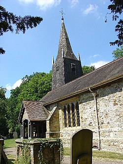
The church of St Bartholomew dates in parts from the 12th century. A later feature is its wooden tower at its west end. Benjamin Ferrey carried a restoration out in 1884-1895.[1]
The rectory in the village dates from the 16th century.