Hownam
| Hownam | |
| Roxburghshire | |
|---|---|
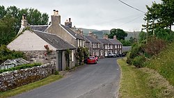
 Hownam village centre | |
| Location | |
| Grid reference: | NT778191 |
| Location: | 55°27’56"N, 2°21’7"W |
| Data | |
| Post town: | Kelso |
| Postcode: | TD5 |
| Dialling code: | 01573 |
| Local Government | |
| Council: | Scottish Borders |
| Parliamentary constituency: |
Berwickshire, Roxburgh and Selkirk |
Hownam is a small village and parish situated eight miles east of Jedburgh in Roxburghshire, close to the border with Northumberland.
Hownam lies south of Morebattle on the Kale Water.[1] The parish borders Northumberland and has, within its boundaries, the Roman road of Dere Street and the Pennymuir Roman camps.[1] Hownam first appears in the written charters in the 12th century.[1] The origin of the name is uncertain, but may indicate a tribal name, "the Hunas".[1] The village itself is a small group of houses in a row on one side of the road.[1] The village church is at the north end of the village.[1] The church was reshaped in the 1750s and further modernised in the 1840s, and again following a fire in 1907.[2]
Local nurseryman George Taylor was born at Hounam Grange in 1803.[3] He emigrated to Kalamazoo, Michigan in 1855, and became known as George "Celery" Taylor because he introduced commercial celery growing to the United States.[3]
References
Outside links
| ("Wikimedia Commons" has material about Hownam) |
