Halfway, Berkshire
| Halfway | |
| Berkshire | |
|---|---|
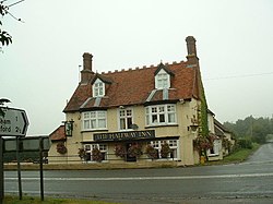
 Halfway Inn, Halfway, Berkshire | |
| Location | |
| Grid reference: | SU407684 |
| Location: | 51°24’47"N, 1°24’54"W |
| Data | |
| Postcode: | RG20 |
| Local Government | |
Halfway is a hamlet close by Welford in Berkshire. It stands on the A4 Bath Road, just north of the multiple streams of the River Kennet. A track leads due south from the village to the river and to a ford across to a little woodland known as "The Wilderness" between the streams.
Elcot, another hamlet barely larger, is to the northwest.
The village is named "Halfway" after the inn of that name, which in turn is named because it stands half way between Newbury and Hungerford on the A4 road.
Notable buildings
A folly-type building used to stand at Halfway, in the shape of a mock castle. This was demolished in the 1960s. It was also the site of 'The Old Green Man' public house, sometimes known as 'The Halfway'. The Halfway Inn is now a Gastropub.[1]
Outside links
| ("Wikimedia Commons" has material about Halfway, Berkshire) |
References
- ↑ "halfwayinn-newbury.co.uk". halfwayinn-newbury.co.uk. http://www.halfwayinn-newbury.co.uk/. Retrieved 2013-02-28.
