Murroes
| Murroes | |
| Angus | |
|---|---|
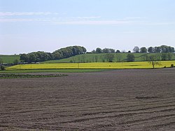
 Farmland south of Murroes | |
| Location | |
| Grid reference: | NO462350 |
| Location: | 56°30’14"N, 2°52’32"W |
| Data | |
| Post town: | Dundee |
| Postcode: | DD4 |
| Dialling code: | 01382 |
| Local Government | |
| Council: | Angus |
| Parliamentary constituency: |
Dundee East |
Murroes is a village and parish in Angus, 3 miles north of Dundee city centre.
The parish church was built in 1848. Ballumbie House, and Powrie, and Wedderburn castles are within the parish. In the reign of King Charles II the minister was Robert Edward, author of an account of Forfarshire. His son was the non-juror Alexander Edward, who later became a notable architect and landscape architect.
References
- Groome, Francis (ed.) (1882-85). "Ordnance Gazetteer of Scotland". Gazetteer for Scotland. http://www.scottish-places.info/towns/townhistory4222.html.
This Angus article is a stub: help to improve Wikishire by building it up.