Ladybank
| Ladybank | |
| Fife | |
|---|---|
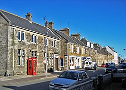
 Commercial Street, Ladybank | |
| Location | |
| Grid reference: | NO306096 |
| Location: | 56°16’28"N, 3°7’19"W |
| Data | |
| Population: | 1,582 (2006 est.) |
| Post town: | Cupar |
| Local Government | |
| Council: | Fife |
| Parliamentary constituency: |
North East Fife |
Ladybank is a town in Fife, 5 miles southwest of Cupar. It stands close to the River Eden.
The town is in the Howe of Fife, a narrow low-lying plain that follows the course of the River Eden, known for its agriculture.
History
Before the 18th century, this area was mostly marshland. In 1247 Roger de Quincy, 2nd Earl of Winchester granted the monks of Lindores Abbey the right to cut peat from a peat-moss called Monegre,[1] to which monks gave the name Our Lady's Bog[2] (the southwestern part of the village is still called Monkstown). Over time this name was shortened to Ladybog.[3]
When the Edinburgh and Northern Railway was constructed in the 1840s, a junction was built here with lines heading towards Perth and Dundee. An engine depot (of which only the disused locomotive shed survives) and a railway station were constructed at the junction. The station was named 'Ladybank Station' rather than 'Ladybog Station',[4] and the village that developed around the station took the name Ladybank. The Fife and Kinross Railway, which opened in 1857, used Ladybank as its eastern terminus further increasing the importance of the station. Ladybank railway station remains largely unaltered, and may be the oldest unaltered station in Scotland.
The village became a burgh in 1878, and became an industrial centre, with linen weaving, coal mining, and malting the principal industries.
Sights of the town
Ladybank Parish Church was constructed in 1874–76 by architects Peddie & Kinnear.[5] Ladybank golf course was founded in 1879 and a six-hole course designed by Old Tom Morris. The course was expanded to 18 holes in 1961 and has been used as a qualifier for The Open Championship.[6]
Transport links
The main road transport route through Ladybank is the A92, which runs along the western edge of the town connecting with Dundee to the north and the M90 motorway to the south.
Ladybank railway station is a mainline railway station with regular service on routes between Edinburgh and Dundee/Perth.
Outside links
References
- ↑ Dowden, John, ed (1903). Chartulary of the Abbey of Lindores, 1195-1479. Edinburgh: The University Press. pp. 178–180.
- ↑ Johnston, James Brown (1903). Place-names of Scotland (2nd ed.). Edinburgh: David Douglas. pp. 192. OCLC 2204716.
- ↑ Laing, Alexander (1876). Lindores Abbey and its Burgh of Newburgh: their history and annals. Edinburgh: Edmonton and Douglas. p. 78.
- ↑ Barrett, Michael (1900). "Scottish Benedictine Houses of the Past". The Dublin Review. 126. London: Burns and Oates. p. 292.
- ↑ Gifford, John (1988). Fife. Yale University Press. p. 302. ISBN 0-300-09673-9.
- ↑ Campbell, Malcolm; Satterly, Glynn (1999). "Ladybank". The Scottish Golf Book. Sports Publishing LLC. pp. 111–113. ISBN 1-58382-053-1.