Slieve Croob
| Slieve Croob | |||
| County Down | |||
|---|---|---|---|

| |||
| Range: | Dromara Hills | ||
| Summit: | 1,752 feet J318453 | ||
Slieve Croob is the tallest of the Dromara Hills, a group of peaks in the middle of County Down between Dromara in the north and Castlewellan in the south. These hills lie north of the Mourne Mountains. A number of communications relay stations are located on the summit of Slieve Croob, both commercial and governmental.
Slieve Croob has been designated an Area of Outstanding Natural Beauty. It is the source of the River Lagan, which starts as a spring and runs from here, through Dromara, Dromore, County Down, Lisburn and Belfast, where it enters Belfast Lough.
The name of the hil is from thr Gaelic Sliabh Crúibe, meaning "mountain of the hoof".[1]
Folklore
Folklore tells that 12 kings are buried at the top of the Mountain and each year it is traditional to climb the hill on the first Sunday in August (known as Cairn Sunday or Blaeburry Sunday) and carry with you a stone to help bury the kings. In recent times there is traditional Irish music played at the top of the Mountain on this date.
Places of interest
- Legannany Dolmen is nine miles southeast of Banbridge and three miles north of Castlewellan, on the slopes of Slieve Croob near the village of Leitrim,[2]
Pictures
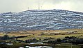
Slieve Croob from the west, covered with patches of snow
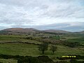
Cratlieve (left), Slieve Croob (middle) and Slievenisky (right) from the south
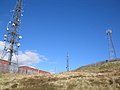
Communications towers on Slieve Croob
_-_geograph.org.uk_-_1739100.jpg)


References
- ↑ Mills, A. D. (2003). A Dictionary of British Place-Names. Oxford University Press. http://www.oxfordreference.com/views/ENTRY.html?subview=Main&entry=t40.e12032. Retrieved 2009-01-20.
- ↑ "Banbridge". Travel Now. http://dg.ian.com/index.jsp?cid=1&action=viewLocation&locationId=30977. Retrieved 2007-12-11.