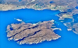
Isle Ristol
| Isle Ristol Gaelic: Eilean Ruisteil | |
 Isle Ristol from the air | |
|---|---|
| Location | |
| Location: | 58°2’38"N, 5°26’13"W |
| Grid reference: | NB971112 |
| Area: | 556 acres |
| Highest point: | 233 feet |
| Data | |
| Population: | 0 |
Isle Ristol, the innermost of the Summer Isles of Cromartyshire. It is a Scottish Wildlife Trust Reserve.
The island lies roughly 12 miles north of Ullapool on the mainland of Cromartyshire. It is a tidal island that is separated by a narrow channel from Old Dorney Bay. Access is by boat from Old Dornie.
The island's name is originally from Old Norse by way of Gaelic, meaning in "island with the horse valley" (Hross dalr ey in Old Norse).
Over fifty higher species have been identified amongst the flora on the Isle Ristol machair, amongst which are moonwort and adder's tongue.[1]
Isle Ristol was a site of a British Fishery Society station in the late 18th century.[2]
References
- ↑ "SWT Reserve: Isle Ristol". Archived from the original on 2007-07-14. http://web.archive.org/web/20070714132948/http://www.swt.org.uk/wildlife/popup_reserves/north/isleristol.htm. Retrieved 2007-07-16.
- ↑ Haswell-Smith, Hamish (2004). The Scottish Islands. Edinburgh: Canongate. ISBN 1841954543.
| The Summer Isles, Cromartyshire |
|---|
|
Bottle Island • Eilean Dubh • Horse Island • Isle Martin • Priest Island • Isle Ristol • Tanera Beag • Tanera Mòr |
