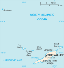
The Valley, Anguilla
| The Valley | |
| Anguilla | |
|---|---|
 Location of The Valley | |
| Location | |
| Location: | 18°13’15"N, 63°3’6"W |
| Data | |
| Population: | 1,169 (2001) |
| Local Government | |
The Valley is the capital of the British overseas territory of Anguilla, and the island's main settlement. It has a population of 1,169.[1]
The Valley has few examples of colonial architecture due to the relocation of Anguilla's administration to St Kitts in 1825, though Wallblake House, built in 1787, still stands and is used as a rectory by the adjacent church. New shops have opened in new buildings and renovated West Indian-style cottages. Old shops have been modernized and have enlarged their stocks as well as their space.
The ruins of the Old Court House are located on Crocus Hill, the island's highest point. All that remains are the broken walls of a few basement jail cells.
At Cross Roads at the western edge of The Valley is Wallblake House, a plantation home built around 1787 that is now owned by the Roman Catholic Church (the parish priest lives there) and St Gerard's Catholic Church, with its highly original facade of pebbles, stones, cement, wood and tile.
The Valley is served by Anguilla Wallblake Airport] (IATA: AXA, ICAO: TQPF) with some international flights.
Outside links
References
- ↑ "Number of Dwellings and Persons for Censuses 1974 - 2001 (Table 2)". Statistics Department of Anguilla. http://gov.ai/statistics/census/Housing%20and%20Household.htm. Retrieved 2008-04-16.