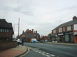
Bentley, West Riding
| Bentley | |
| Yorkshire West Riding | |
|---|---|
 A19 road through Bentley | |
| Location | |
| Grid reference: | SE565056 |
| Location: | 53°33’4"N, 1°8’38"W |
| Data | |
| Population: | 14,191 (2011) |
| Post town: | Doncaster |
| Postcode: | DN5 |
| Dialling code: | 01302 |
| Local Government | |
Bentley is a suburb of Doncaster in the West Riding of Yorkshire, two miles north of the town centre. The population of the ward at the 2011 Census was 14,191.[1] The village was once owned by Edmund Hastings of Plumtree, Nottinghamshire, who had inherited it from his wife Copley's Sprotborough family. Hastings subsequently sold the manor to John Levett, a York lawyer born at High Melton who married the niece of Hastings's wife, who then conveyed it to Sir Arthur Ingram of York, High Sheriff of Yorkshire.[2][3]
A former mining village, it lies on the River Don. Bentley and the nearby hamlet of Toll Bar were badly affected by floods in June 2007.
Bentley is made up of many parts; West End, New Village and Rostholme. Streets in Bentley include Cooke Street and High Street.
References
- ↑ "Doncaster ward population 2011". Neighbourhood Statistics. Office for National Statistics. http://www.neighbourhood.statistics.gov.uk/dissemination/LeadKeyFigures.do?a=7&b=13689508&c=Bentley&d=14&e=62&g=6354154&i=1001x1003x1032x1004&m=0&r=1&s=1457269893692&enc=1. Retrieved 6 March 2016.
- ↑ The Topographer and Genealogist editor John Gough Nichols, 1858.
- ↑ Deeds between Hastings and Levetts, Cooke of Wheatley Muniments, Sheffield Archives, The National Archives, nationalarchives.gov.uk
Outside links
- Bentley Explosion at 7am Sunday 13 June 2010
- Flood pictures 2007
- BBC News - Residents braced for more floods, 30 June 2007
- BBC News - Misery goes on for flood villages, 2 July 2007
- Conveyance of Bentley, The Topographer and Genealogist, John Gough Nichols, 1858

This Yorkshire article is a stub: help to improve Wikishire by building it up.