Pennington, Hampshire
| Pennington | |
| Hampshire | |
|---|---|
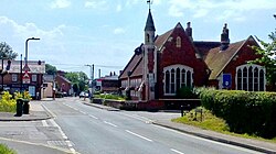
 Pennington, The Square | |
| Location | |
| Grid reference: | SZ313945 |
| Location: | 50°44’58"N, 1°33’23"W |
| Data | |
| Population: | 6,060 |
| Post town: | Lymington |
| Postcode: | SO41 |
| Dialling code: | 01590 |
| Local Government | |
| Council: | New Forest |
| Parliamentary constituency: |
New Forest West |
Pennington is a village in the New Forest in the south-west of Hampshire consisting of two hamlets; Upper Pennington to the north and Lower Pennington to the south.
The population taken at the 2011 census was 6,060. It is in the southernmost part of the New Forest on the Solent coastline near to the town of Lymington.
Pennington sits on the river terrace plateau between Avon Water to the west and Yaldhurst stream to the east. The hamlet of Bowling Green is in Upper Pennington on the border with Sway.
About the village

Pennington Village is the main historical settlement and is where major residential development throughout the twentieth century was concentrated. Most of Pennington's shops are located in the village along with a majority of Pennington's schools. Pennington Village also has a leisure centre, which has a 25-metre indoor swimming pool, a sports hall, a gym, and an astro-turf football pitch.
Lower Pennington is home to important local infrastructure including a solar farm, a water treatment works, a recycling centre, and certain landfill sites, as well as a number of farms. Oakhaven Hospice is located in Lower Pennington.
Pennington Common and Pennington Recreation Ground are open spaces used for sports and local community events.
Pennington and Oxey Marshes, historically the largest salt pans in the area, are popular spots for bird watching, walking, fishing, photography and cycling.
Pennington Common and Upper Common are designated Sites of Special Scientific Interests ('SSSIs'). Pennington and Oxey Marshes are divided into 11 designated SSSIs (references listed below).
St Marks Church
St Marks Church is located at the southern end of Pennington Common, within the village, and is part of the Diocese of Winchester.
About the village
To the south of Pennington lie Pennington and Oxey Marshes, an area of marsh and tidal muds, formerly used as salterns for the local salt industry. These form part of the larger North Solent Marshes.
These are a favourite area for local birdwatchers and photographers, and many different types of bird have been spotted here.[citation needed]
The Solent Way, a regional coastal path, runs through the area atop the sea wall. There are also walking, cycling and running routes signposted, which are maintained by Hampshire County Council.
New Forest National Park Authority has planning authority over the marshes area.
The mudflats and salt marshes outside the seawall are leased by Hampshire and Isle of Wight Wildlife Trust and form their Keyhaven and Pennington Marshes Reserve.
Pennington and Oxey marshes are divided into 11 designated Sites of Special Scientific Interest (see Natural England [1] references 3, 4, 7, 8, 9, 10, 12, 17, 18, 19 and 23).
Pennington Common
Pennington Common and Upper Common are designated Sites of Special Scientific Interest (see Natural England [2] references 197, 198, and 199).
Pennington Common was rated Silver Gilt and "Common of the Year" in 2016's Britain in Bloom - South and South East.[1]
Outside links
| ("Wikimedia Commons" has material about Pennington, Hampshire) |
References
- Stephens, Joan:
- 'Pennington Remembered – A Pictorial Recollection': (Eon Graphics, 1990)
- 'Snippets from long ago in Pennington' (Eon Graphics, 2004)
- 'Pennington's Sacrifice in the Great War' (Natula Publications, 2007)
