East Dean, Eastbourne
| East Dean | |
| Sussex | |
|---|---|
 Dene Side, East Dean | |
| Location | |
| Grid reference: | TV556976 |
| Location: | 50°45’27"N, -0°12’21"E |
| Data | |
| Population: | 1,675 (2011) |
| Post town: | Eastbourne |
| Postcode: | BN20 |
| Dialling code: | 01323 |
| Local Government | |
| Council: | Wealden |
| Parliamentary constituency: |
Lewes |
| Website: | eastdeanvillage.org.uk |
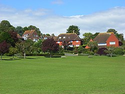
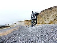
East Dean is a village in the east of Sussex, in the South Downs to the west of Eastbourne and a mile inland of the south coast. It stands immediately south of the larger village of Friston. A lane runs due south to the hamlet at Birling Gap, where there is a small beach, but otherwise the coast here is cliff-bound, culminating in Beachy Head, two miles west of Birling Gap.
The village sits in a dry valley on the South Downs, between Eastbourne three miles to the east and Seaford an equal distance to the west. The main A259 road goes through both village centres. The coast and much of the land between it and the A259 from the east edge of Seaford to the west edge of Eastbourne is owned by the National Trust, and this has prevented further development to the area.

Parish church
The church in East Dean, dedicated to St Simon and St Jude, has a Saxon tower and an unusual Tapsel gate (preventing cattle from entering the churchyard).
Another church is in Friston, St Mary The Virgin, which has formed a united benefice since 1688 with East Dean.
Outside links
| ("Wikimedia Commons" has material about East Dean, Eastbourne) |

