Lower Wick
| Lower Wick | |
| Gloucestershire | |
|---|---|
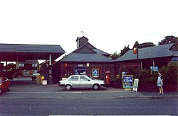
 Lower Wick post office | |
| Location | |
| Grid reference: | ST710966 |
| Location: | 51°40’5"N, 2°25’14"W |
| Data | |
| Postcode: | GL11 |
| Local Government | |
| Council: | Stroud |
Lower Wick is a small hamlet in Gloucestershire, strung along a lane which is overleapt here by the M5 motorway. It is to be found about five miles south west of Dursley, eighteen miles south-west of Gloucester and fifteen miles north-east of Bristol.
By the village is a woodland sliced in twain by the motorway, known as Michael Wood, better known to travellers for the Michaelwood Services on the motorway.
The hamlet contains approximately 17 homes (including the old schoolhouse, now converted into a dwelling) and a restaurant. Most of the older properties were built by the Berkeley family who once owned much of the land.
One of the farms in the hamlet still has a working wind pump in use today which is over one hundred years old.
Outside links
| ("Wikimedia Commons" has material about Lower Wick) |
