Ringmore
| Ringmore | |
| Devon | |
|---|---|
 Ringmore, Devon | |
| Location | |
| Grid reference: | SX652459 |
| Location: | -3.894,/zoom=13 50.298, -3.894 |
| Data | |
| Population: | 208 (2011) |
| Local Government | |
| Council: | South Hams |
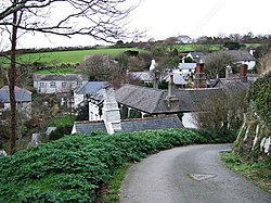
Ringmore is a village close by the south coast of Devon, between Kingston just over a mile to the north-west and Bigbury a mile to the east, while Bigbury-on-Sea, at the mouth of the River Avon sits to the south.
Ringmore itself has paths running the short distance to the sea in Bigbury Bay, on the English Channel, and to the little sea-bound stream above whose valley the village stands. The stream enters the sea here forming at its mouth Aymore Cove, from where Ringmore's fishing boats were long wont to sail.

The village has two notable buildings: the Church of All Hallows, a 13th-century church, and The Journey's End inn, previously known as 'The New Inn', built in the 18th or early 19th century.[1] The inn is a Grade II listed building.[2]
The parish population at the 2011 census was just 208.
History
Ringmore is first recorded in the Domesday Book, in which it is named "Reimore". Until 1908, there was a manor (or estate) located in Ringmore. Due to the absence of a lord in the manor, there are no official written records of the past of the village.
The small sandy bay located at the coast, Aymore Cove, was once Ringmore's "port". From here the boats departed that went fishing for pilchards and to rescue seafarers wrecked on the rocks near Burgh Island.[3]
Parish church

The parish church is All Hallows. The present church building was built around 1240, thoufh there are traces of earlier work, of the twelfth century. The tower was added in the 14th century. It has changed little externally from that time. Windows were added in the Victorian period.
The church is a Grade II* listed building,[4]
About the village
The parish of Ringmore extends to 1,128 acres and includes at its southern boundary the shoreline hamlet of Challaborough and, to the north, a group of houses at Marwell. Most of its land is owned by the National Trust, and a large part of the village is designated as a Conservation Area.
By common consent there is no street lighting and there is, from 2017, a mobile phone mast near the village (close to St Anne’s Chapel).[3]
Outside links
References
- ↑ Ringmore.info
- ↑ National Heritage List 1325113: Journey's End Inn
- ↑ 3.0 3.1 Ringmore History
- ↑ National Heritage List 1108047: All Hallows Church