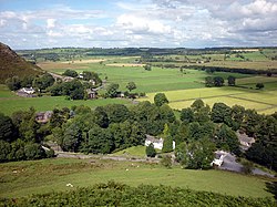
Mungrisdale
| Mungrisdale | |
| Cumberland | |
|---|---|
 Mungrisdale | |
| Location | |
| Grid reference: | NY3630 |
| Location: | 54°39’47"N, 2°59’20"W |
| Data | |
| Population: | 297 (2011) |
| Post town: | Penrith |
| Postcode: | CA11 |
| Dialling code: | 01768 |
| Local Government | |
| Council: | Westmorland & Furness |
| Parliamentary constituency: |
Penrith and The Border |
Mungrisdale is a small village in Cumberland, north-east of the Lake District proper and its fell country but within area in which fellwalkers congregate and far from lacking in its own delights. The name 'Mungrisdale' is also that of the valley in which the village sits.
The name of the dale, and hance the village, is from the Old Norse language: 'gris dalr' means "Pig Valley", and the prefix refers to St Mungo, otherwise called Kentigern: a popular saint for dedications in the Middle Shires, from whom the parish church is named.
Mungrisdale is a popular starting point for ascents of the nearby hills, such as Bowscale Fell, Bannerdale Crags and Souther Fell.
The parish, including neighbouring hamlets, had a population of 297 recorded at the 2011 census. The village has no local amenities except for the church and a pub.
Parish church
The parish church is St Kentigern's Church, built in 1756. It is a Grade II* listed building.[1]
Outside links
| ("Wikimedia Commons" has material about Mungrisdale) |
References
- ↑ National Heritage List 1137800: Church of St Kentigern, Mungrisdale
