Conwy
| Conwy | |
| Caernarfonshire | |
|---|---|
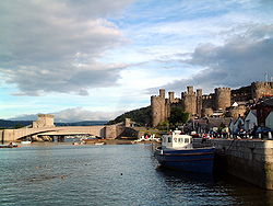
 Conwy Castle and the bridges | |
| Location | |
| Grid reference: | SH775775 |
| Location: | 53°16’48"N, 3°49’48"W |
| Data | |
| Population: | 14,208 (2001) |
| Post town: | Conwy |
| Postcode: | LL32/LL31 |
| Dialling code: | 01492 |
| Local Government | |
| Council: | Conwy |
| Parliamentary constituency: |
Aberconwy |
Conwy (also spelled Conway) is a walled market town on the north coast of Caernarfonshire. The town faces Deganwy across the River Conwy. It is a popular tourist destination.

Conwy Castle and the town walls were built, on the instruction of King Edward I between 1283 and 1289, as part of his subjection of North Wales. The town's mediæval walls are a rare survival.
Conwy was the original site of Aberconwy Abbey, founded by Llywelyn the Great, but when King Edward I took the abbey site over, the monks were moved down the Conwy Valley to a new site at Maenan. The parish church still retains some parts of the original abbey church in the east and west walls. English settlers were given incentives to move to the walled garrison town, which for decades the Welsh were forbidden from entering.
Across the estuary is Bodysgallen Hall, which incorporates a mediæval watchtower that was later used as a signal place for Conwy Castle.
Houses great and small
Aberconwy House is Conwy's only surviving 14th-century merchant's house. It now belongs to the National Trust
Another fine house open to the public is Plas Mawr, an Elizabethan house built in 1576 by the Wynn family. It has been refurbished extensively to its original 16th-century appearance and is now in the care of Cadw.[1]
The house named in the Guinness Book of Records as "The Smallest House in Great Britain", with dimensions of 10 feet x 6 feet, stands on the quay. It was in continuous occupation by individuals and families from the 1500s until 1900, when the owner a (6 foot fisherman named Robert Jones) was forced to move out on the grounds of hygiene. The rooms were too small for him to stand up in fully. The house is still owned by his descendants today, and visitors can go on a tour around it for a small charge.

Conwy Morfa
Conwy Morfa is a marshy spit of land on the west side of the estuary. It was probably the location where golf was first played in Wales.
On Conwy Morfa Hugh Iorys Hughes developed and later built the floating Mulberry Harbour, which "Mulberries" were towed to the Normandy beaches following the D-Day landings as part of in Operation Overlord in 1944. .

Bridges and tunnels
Conwy Suspension Bridge, completed in 1826, was designed by Thomas Telford to replace the ferry. It spans the River Conwy next to the castle. Telford designed the bridge's supporting towers to match the castle's turrets. The bridge is now open to pedestrians only and, together with the toll-keeper's house, is in the care of the National Trust.
The Conwy Railway Bridge is a tubular bridge built for the Chester and Holyhead Railway by Robert Stephenson in 1849. The bridge is still in use on the North Wales Coast Line. The town's station is located within the town walls.
A modern road bridge crosses the river to the town. The A55 though passes under the river by a tunnel built between 1986 and 1991. The old mountain road to Penmaenmawr runs through the Sychnant Pass, at the foot of Conwy Mountain.