Carleton Forehoe
| Carleton Forehoe | |
| Norfolk | |
|---|---|
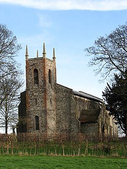
 St mary’s, Carleton Forehoe | |
| Location | |
| Grid reference: | TG091055 |
| Location: | 52°36’26"N, 1°5’15"E |
| Data | |
| Postcode: | NR9 |
| Local Government | |
| Council: | South Norfolk |
Carleton Forehoe is a hamlet in Norfolk. It is separated from Kimberley by Kimberley Park, the parkland estate of Kimberley Hall, the main entrance to which is by Carleton Forehoe.
The hamlet is in the middle of the county, three miles north of Wymondham. The brook running through the village joins the young River Yare a little way downstream at Barford
Church
The parish church is St Mary The Virgin. The church is found in the middle of a field: access by car is by driving over the meadow. Internally it has a rare minstrels’ gallery and traditional hand-pumped organ.
The parish is now part of a wider rural benefice united fifteen churches in thirteen parishes known as 'The Barnham Broom and Upper Yare Team of Parishes'.
Outside links
| ("Wikimedia Commons" has material about Carleton Forehoe) |
