Widdrington Station
| Widdrington Station | |
| Northumberland | |
|---|---|
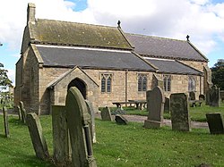
 Parish Church, to The Holy Trinity | |
| Location | |
| Grid reference: | NZ247939 |
| Location: | 55°14’27"N, 1°36’50"W |
| Data | |
| Population: | 2,767 (2011) |
| Post town: | Morpeth |
| Postcode: | NE61 |
| Dialling code: | 01670 |
| Local Government | |
| Council: | Northumberland |
| Parliamentary constituency: |
Berwick upon Tweed |
Widdrington Station is a village in Northumberland, a mile south of Widdrington Village, close to the North Sea coast. It is beside and barely separated from the neighbouring hamlet, Stobswood. The three, Widdrington, Widrington Station and Stobswood, together had 2,767 residents recorded at the 2011 census.
The village is to be found six miles north of Morpeth.
The name of the village, as it suggests, is from the railway station here. A station was built to serve Widdrington on what is now the East Coast Main Line, but as the line passes a mile from the village the station was at a distance from the village. A little village grew up around the station and took its name from it: Widdrington Station.
Landmarks
Widdrington Station has four food premises including The Junction restaurant and Sidings Bar which includes in its menu items a traditional speciality dish that is local to the region, beer battered black pudding.[1] The village has its own library, medical centre and a modern mini-supermarket, which is a Co-op.

Outside links
| ("Wikimedia Commons" has material about Widdrington Station with Stobswood) |
References
- ↑ "About Us". Thejunctionrestaurant.co.uk. http://www.thejunctionrestaurant.co.uk/about-us/. Retrieved 2013-04-22.
