Appletreehall
| Appletreehall | |
| Roxburghshire | |
|---|---|
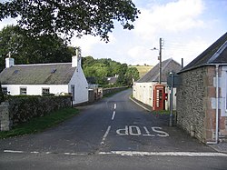
 Appletreehall from the main road | |
| Location | |
| Grid reference: | NT518174 |
| Location: | 55°26’56"N, 2°45’47"W |
| Data | |
| Post town: | Hawick |
| Postcode: | TD9 |
| Dialling code: | 01450 |
| Local Government | |
| Council: | Scottish Borders |
| Parliamentary constituency: |
Berwickshire, Roxburgh and Selkirk |
Appletreehall is a tiny village in Roxburghshire, 2 miles north-east of Hawick, and the same distance from the River Teviot. The Boonraw Burn flows down through Appletreehall towards the river.
Nearby are Branxholme, Broadhaugh, Roberton, Wilton and Wilton Dean.
Outside links
| ("Wikimedia Commons" has material about Appletreehall) |
- CANMORE (RCAHMS) record of Hawick Appletreehall
- Photographs of Hawick, with road bridge between Appletreehall crossroads and the A698
- E-book: Manuscripts of the duke of Athole, K.T., and of the Earl of Home
References
- NMS (1995c), 'Appletreehall, Hawick (Hawick parish), Romano-British sculptured figure of deity', Discovery Excav Scot National Museums of Scotland, page 9
This Roxburghshire article is a stub: help to improve Wikishire by building it up.