New Abbey
| New Abbey | |
| Kirkcudbrightshire | |
|---|---|
 Sweetheart Abbey, in New Abbey | |
| Location | |
| Location: | 54°58’48"N, 3°37’10"W |
| Data | |
| Population: | 82 (2001) |
| Post town: | Dumfries |
| Postcode: | DG2 |
| Dialling code: | 01387 |
| Local Government | |
| Council: | Dumfries and Galloway |
| Parliamentary constituency: |
Dumfries and Galloway |
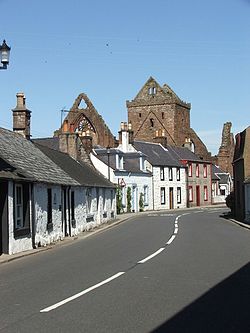
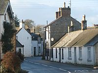
New Abbey is a village in Kirkcudbrightshire. It is around eight miles southwest of Dumfries. The summit of the prominent hill Criffel is two and a half miles to the south.
The village has a wealth of history including the ruined Cistercian abbey Sweetheart Abbey, founded by Dervorguilla of Galloway in 1273 to commemorate the death of her husband John Balliol, King of Scots. The monks named the abbey dulce cor ('Sweet heart').
The village has a watermill, the New Abbey Mill.[1]
Churches
- Church of Scotland: New Abbey Church
- Roman Catholic

About the village
The village has a saw mill, two hotels, a village shop, a coffee shop, a primary school, a doctor's surgery, a village hall, a bowling green, a football pitch, its two churches and the Shambellie House Museum of Costume.
Loch Kindar has a crannog and the village has the remains of Kirk Kindar (this was the parish church until just after 1633 when it was transferred to the refectory of the suppressed Sweetheart Abbey) on an island located just outside the village.
The village has many walks on offer including the steps up to the Waterloo Monument. Two burns flow through the village, of which the New Abbey Pow runs into the Nith Estuary, and the Sheep Burn.
Sport
- Football: Abbey Vale FC, who play at Mayfield Park in the village
Outside links
| ("Wikimedia Commons" has material about New Abbey) |
- Parish of New Abbey in Kirkcudbrightshire
