Botley, Berkshire
| Botley | |
| Berkshire | |
|---|---|
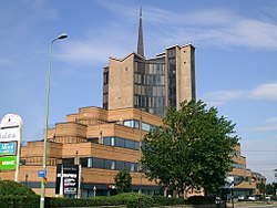
 Seacourt Tower | |
| Location | |
| Grid reference: | SP483060 |
| Location: | 51°45’0"N, 1°17’53"W |
| Data | |
| Post town: | Oxford |
| Postcode: | OX2 |
| Dialling code: | 01865 |
| Local Government | |
| Council: | Vale of White Horse |
| Parliamentary constituency: |
Oxford West and Abingdon |
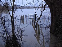
Botley is a village of northern Berkshire near North Hinksey. It stands on the Seacourt Stream, a stream running off the River Thames, just west of Oxford. The Seacourt Stream is just to the west of the village, while New Botley lies in the meadowland between the stream and the main course of the River Thames, the county boundary across which lies the City of Oxford.
The A34 Oxford ring road carves its way across the land through Botley, and the A420 comes off it here to, heading to Swindon.
Botley is effectively a suburb of Oxford, a largely residential area with property prices ranging from relatively cheap in some places, to very expensive, in the direction of Cumnor. The hamlet of Dean Court adjoins Botley, in the parish of Cumnor.
Buildings
The parish church is St Peter and St Paul, built in 1958.
Botley includes a small local shopping centre at Elms Parade. Elms Parade was built in 1937 by Stephen Howse. The site is still owned by the Howse family. A small precinct called West Way Shopping Centre; a small retail complex, was opened in 1968.
The various large office buildings along the main road include Seacourt Tower, known locally as "Botley Cathedral" owing to its small metal spire, originally built in 1965-66 as a car showroom and garage to a design by Beecher and Stamford.[1] It is still owned by Hartwell Ford.
History
Botley was first settled in the Early Saxon period. Its Name comes from the Old English Botan leag; Bota's woodland clearing.[2] It falls within the parish of North Hinksey.
Because the main road west out of Oxford has passed through Botley since the 16th century, development since then was centred here rather than in the village of North Hinksey itself, slightly further south. From the 1880s the centre of the village began to be called Old Botley, in distinction to the New Botley development along Botley Road in Oxford.[3] The name Old Botley is preserved in a street set back from the main road. The major development which began in the 1930s took place to the west, beyond the current ring road.
To the north of Botley was the lost village of Seacourt. The site of the former village is in neighbouring Wytham parish, but it is commemorated in Botley in the names of the Seacourt Stream, the Seacourt Tower, the Seacourt Bridge public house and the nearby park and ride site.
Outside links
References

Sources
- Hanson, John (1995). The Changing Faces of Botley and North Hinksey. Witney: Robert Boyd. pp. 7, 26.
- Sherwood, Jennifer; Pevsner, Nikolaus (1974). Oxfordshire. The Buildings of England. Harmondsworth: Penguin Books. pp. 335. ISBN 0 14 071045 0.