Wytham
| Wytham | |
| Berkshire | |
|---|---|
 Wytham | |
| Location | |
| Grid reference: | SP4708 |
| Location: | 51°46’41"N, 1°18’47"W |
| Data | |
| Population: | 131 (2001) |
| Post town: | Oxford |
| Postcode: | OX2 |
| Dialling code: | 01865 |
| Local Government | |
| Council: | Vale of White Horse |
| Parliamentary constituency: |
Oxford West and Abingdon |
| Website: | Wytham Village |
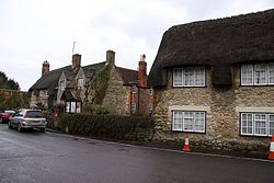
Wytham is a village in northern Berkshire on Seacourt Stream, a branch of the River Thames, about three miles north-west of Oxford. It is tucked just west of the Western By-Pass Road, part of the Oxford Ring Road.
The village's name is first recorded as Wihtham around 957, and comes from the Old English for a homestead or village in a river-bend.[1]
The manor of Wytham along with Wytham Abbey (not a religious foundation but the manor house) and much of the village was formerly owned by the Earls of Abingdon. The parish church of All Saints is a mediæval building extensively rebuilt between 1811[2] and 1812[3] by Montagu Bertie, 5th Earl of Abingdon.
Wytham Woods is an area of long-established mixed woodland noted for their high population of badgers and long-term monitoring of great tits. The woods are a Site of Special Scientific Interest. The University of Oxford owns the woods and uses them for research in zoology and climatology. The University also has a field station north of the village.
Picture gallery
-
All Saints' parish church
-
Keepers Cottage, Wytham Woods, a gift to the University of Oxford in 1943
Outside links
| ("Wikimedia Commons" has material about Wytham) |
- Wytham Village Hall
- All Saints Church, Wytham
- Nature Conservation in Wytham Woods
- Wytham Woods SSSI citation
References
Sources
- Mills, A.D.; Room, A. (2003). A Dictionary of British Place-Names. Oxford: Oxford University Press. p. not cited. ISBN 0198527586.
- Page, W.H.; Ditchfield, P.H., eds (1924). A History of the County of Berkshire, Volume 4. Victoria County History. pp. 427–430.
- Pevsner, Nikolaus (1966). Berkshire. The Buildings of England. Harmondsworth: Penguin Books. p. 314.

