Ben Armine
| Ben Armine | |||
| Sutherland | |||
|---|---|---|---|
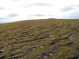
 The bare summit of Ben Armine (Creag a' Choire Ghlais) | |||
| Range: | Ben Armine Forest | ||
| Summit: | 2,313 feet NC69482731 58°12’55"N, 4°13’24"W | ||
Ben Armine is a mountain of 2,313 feet standing at the northern edge of the Ben Armine Forest of Sutherland, a treeless mountain fastness separated from Ben Klibreck to the west by the glen in which lies Loch Chloire. The streams that feed the Black Water rise on the mountain's highest slopes, and those that create the River Brora on the wider slopes of the Ben Armine Forest.
The summit of Ben Armine itself, at 2,313 feet, is known as Creag a' Choire Ghlais ('Crag of the green corrie'). It is a appropriately named, standing as it does above a precipitous crag dropping down to the low, marshy grounds to the east.
Surpassing this summit however is another of the many tops of the high gorund of the Forest, Creag Mhòr, at 2,339 feet.
The Ben Armine Forest
The Ben Armine Forest is a forest in the old sense, of an open expanse, not a woodland, and this forest is treeless. It is an upland in the centre of Sutherland and which extends between Loch Choire at its north-western edge, the edges of the Flow Country in the east, and the beginnings of the gentler grond in the south. The Forest is drained by innumerable burns, the main waters fowing down from its slopes being the River Brora and its eventual tributary the Black Water, which head south-eastwards towards the sea.
Outside links
| ("Wikimedia Commons" has material about Ben Armine) |
- Ben Armine and Craig Mhor walk - WalkHighlands
