Tregare
| Tregare Welsh: Tre'r-gaer | |
| Monmouthshire | |
|---|---|
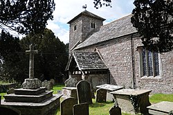
 St Mary's Churchyard cross | |
| Location | |
| Grid reference: | SO417102 |
| Location: | 51°47’15"N, 2°50’48"W |
| Data | |
| Population: | 197 |
| Post town: | Usk |
| Postcode: | NP15 |
| Dialling code: | 01291 |
| Local Government | |
| Council: | Monmouthshire |
| Parliamentary constituency: |
Monmouth |
Tregare is a village and ancient parish on the northern border of the Raglan Hundred of Monmouthshire. It is located two miles north of Raglan in deeply rural Monmouthshire.
History and amenities
The village is served by a church, dedicated to St Mary. Dating originally from the fourteenth century, the tower is later, probably of the fifteenth century. The church was restored in the early twentieth century. Built in the Decorated style, the church is a Grade-II* listed building.
Tregare is bisected by the old coaching road from Abergavenny to Monmouth, along which Mail coaches or stagecoaches must have run and two of the original coachhouses, now converted into residential properties, remain in the village.
Outside links

This Monmouthshire article is a stub: help to improve Wikishire by building it up.