Stobo
| Stobo | |
| Peeblesshire | |
|---|---|
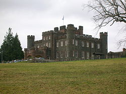
 Stobo Castle | |
| Location | |
| Grid reference: | NT184375 |
| Location: | 55°37’29"N, 3°17’50"W |
| Data | |
| Post town: | Peebles |
| Postcode: | EH45 |
| Dialling code: | 01721 |
| Local Government | |
| Council: | Scottish Borders |
| Parliamentary constituency: |
Dumfriesshire, Clydesdale and Tweeddale |
Stobo is a small village and parish on the west bank of the River Tweed, in Peeblesshire. It sits beside the B712 road, midway between Lyne to the north and Drumelzier to the south.
Stobo Castle and its extensive estate stand to the south, and a little beyond the Dawyck Botanic Garden, across the Tweed.
This Peeblesshire article is a stub: help to improve Wikishire by building it up.