East Hagbourne: Difference between revisions
Created page with "{{Infobox town |name=East Hagbourne |county=Berkshire |picture=Upper Cross East Hagbourne.jpg |picture caption=Houses at Upper Cross |os grid ref=SU527883 |latitude=51.591 |lo..." |
|||
| Line 78: | Line 78: | ||
*{{cite book |last1=Clare |first1=Brenda |last2=Lawson |first2=Monica |last3=Pereira |first3=Willie |year=1995 |title=East Hagbourne Times: Portrait of an English Village |place=East Hagbourne |publisher=East Hagbourne Parish Council |isbn=0-9527211-0-4 }} | *{{cite book |last1=Clare |first1=Brenda |last2=Lawson |first2=Monica |last3=Pereira |first3=Willie |year=1995 |title=East Hagbourne Times: Portrait of an English Village |place=East Hagbourne |publisher=East Hagbourne Parish Council |isbn=0-9527211-0-4 }} | ||
*{{cite book |last=Fae |first=Allan |year=1913 |title=Quiet roads and sleepy villages |place=London |publisher=E Nash |pages=[https://archive.org/details/quietroadssleepy00feaauoft/page/196 196]–7 |via=Internet Archive |url=https://archive.org/details/quietroadssleepy00feaauoft }} | *{{cite book |last=Fae |first=Allan |year=1913 |title=Quiet roads and sleepy villages |place=London |publisher=E Nash |pages=[https://archive.org/details/quietroadssleepy00feaauoft/page/196 196]–7 |via=Internet Archive |url=https://archive.org/details/quietroadssleepy00feaauoft }} | ||
*{{VCH|3| | *{{VCH|3|Parishes: Hagbourne|pp=475-484}} | ||
*{{Pevsner|pp=132-133 }} | *{{Pevsner|pp=132-133 }} | ||
Revision as of 16:12, 10 February 2024
| East Hagbourne | |
| Berkshire | |
|---|---|
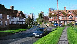 Houses at Upper Cross | |
| Location | |
| Grid reference: | SU527883 |
| Location: | 51°35’28"N, 1°14’20"W |
| Data | |
| Population: | 1,882 (2011) |
| Post town: | Didcot |
| Postcode: | OX11 |
| Dialling code: | 01235 |
| Local Government | |
| Council: | South Oxfordshire |
| Parliamentary constituency: |
Wantage |
| Website: | East Hagbourne Village and Community |
East Hagbourne is a village in Berkshire, found about a mile south of Didcot.
The 2011 Census recorded the parish's population as 1,882.
Manor
The name 'Hagbourne' is derived from Old English, possibly from Hæccan burna, which is to say 'Hacca's Brook', referring to a stream that flows through the village. East Hagbourne was sometimes called Church Hagbourne.[1]
East and West Hagbourne have been separate villages at least since the time of Edward the Confessor, when Regenbald, a priest of Cirencester, held the manor of East Hagbourne. Regenbald continued to hold the manor long after the Norman Conquest of 1066, as is recorded in the Domesday Book of 1086. Regenbald died in the reign of Henry I, who then granted East Hagbourne manor to the Augustinians of Cirencester Abbey (founded 1117).
The abbey continued to hold the manor until 1539, when it surrendered its lands to the Crown in the Dissolution of the Monasteries.[1]
Churches
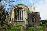
The Church of England parish church, St Andrew's, is a mediaeval, Gothic church, and is a Grade I listed building. It has a nave which may have been built in the 12th century. The south aisle was added early in the 13th century. It is linked with the nave by a three-bays arcade. It was followed a few years later by the south chapel, which is alongside the chancel and linked to it by a two-bay arcade. The chancel arch was built in the middle of the 13th century. The north aisle, also of three bays, was added about 1340, followed by the Decorated Gothic north chapel, which is alongside the chancel and linked with it by a two-bay arcade.[1]
On the floor of the north chapel are monumental brasses commemorating Claricia Wyndesor – quare fieri fecit istam capellam (why did he make this chapel) (died 1403) and her husband John York fundator istius Ile (founder of Ile) (died 1404).[2]
Nikolaus Pevsner takes this to mean that the north chapel was built early in the 15th century, which surprised him as its Decorated Gothic style had been succeeded by Perpendicular Gothic around 1350.[2] However, the south aisle and south chapel were rebuilt in the Perpendicular Gothic style early in the 15th century so Page and Ditchfield conclude that the brasses of Clarice Windsor and John York were formerly in the south chapel and moved at a later date.[2]
The south chapel has a squint into the chancel.[1] The chapel was re-roofed in the 17th century.[2]
The arch supporting the west bell tower is 14th-century Decorated Gothic but the style of the rest of the tower is Perpendicular Gothic.[1][2] A Perpendicular Gothic clerestory was added to the nave in the 15th century. The east window of the chancel is also Perpendicular, from late in the 15th century.[1]
St Andrew's parish is part of the Benefice of the Churn.
A Primitive Methodist chapel was built in East Hagbourne in the 19th century.[1] It is a red brick building with Gothic Revival ashlar stone details. It has ceased to be used for worship and is now a private house.[3]
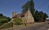
Churches were built for Northbourne when it was still part of Hagbourne parish: St Peter's Church of England church in 1890, a Wesleyan chapel in 1901 and a Primitive Methodist chapel in 1903.[1] St Peter's now has a new building that was completed in 1977, and its old building is the Northbourne Centre. Northbourne has been effectively swallowed into Didcot.
History
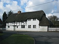
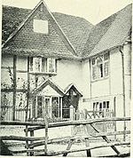
In 1644 during the Civil War, the Parliamentarian army billeted 6,000 horsemen in East Hagbourne. A tiny window, only three inches square, in a house on Main Road, is said to have been used to spy on the Parliamentarian troops.[4]
On 10 March 1659, fire spread through the village, burning down a considerable number of thatched houses.[1] In 1661 King Charles II issued a proclamation requesting aid for the village. A sum was received from Londoners and, in return, East Hagbourne sent money to London after the Great Fire of London in 1666.[5] The Hagbourne fire could explain the number of well-preserved houses from after this era.
The village has numerous old timber-framed houses, both around the village cross and along the main street.[6] Coscote Manor, about half a mile west of the village, is a timber-framed 17th-century house with fretwork bargeboards and an Ipswich window.[7]
Hagbourne Church of England Primary School[8] is in East Hagbourne and was built in 1874.[1]
The Didcot, Newbury and Southampton Railway was built through the parish, passing west of the village and east of Coscote on the still extant Hagbourne Embankment – one of the line's most notable civil engineering features, built upon chalk dug from the route of the line through the Berkshire Downs. The line opened in 1881. There was no station in the parish; the nearest were at Upton and Didcot. In 1911 the Great Western Railway renamed Upton station 'Upton and Blewbury'. In 1942–43 the track was doubled to carry increased war traffic, and the bridges over the West Hagbourne Road & Lake Road were rebuilt. British Railways closed the line to passenger traffic in 1962 & freight in 1967.
About the village
East Hagbourne has a 17th-century pub, the Fleur de Lys.[9][10] It has a Church of England Primary School on Main Road. Opposite the school is Hagbourne village hall, shared by East and West Hagbourne and used regularly for village events.
There is a small Post Office and a village shop in New Road, opened in 2001 and run by local volunteers.[11]
On television
In July 1975, the location scenes for the Doctor Who serial The Android Invasion were filmed in the village.[12] In 1989, Tom Baker, who starred as the Doctor, returned to the village to be interviewed by Nicholas Briggs about his time on Doctor Who for the Reeltime Pictures Myth Makers series. In 2012, Briggs returned to the village to interview residents for The Village That Came to Life, a making-of documentary featured on the DVD release of The Android Invasion.
In 2015, two television channels featured East Hagbourne in reports about the Mind the Green Gap Campaign.[13]
Outside links
| ("Wikimedia Commons" has material about East Hagbourne) |
References
- ↑ 1.00 1.01 1.02 1.03 1.04 1.05 1.06 1.07 1.08 1.09 Page & Ditchfield 1923, pp. 475–484
- ↑ 2.0 2.1 2.2 2.3 2.4 Pevsner 1966, p. 132.
- ↑ "East Hagbourne, Methodist Chapel". Oxfordshire Churches & Chapels. Brian Curtis. http://www.oxfordshirechurches.info/EastHagbourneMethodist.htm.
- ↑ Clare, Lawson & Pereira 1995, p. 50
- ↑ Clare, Lawson & Pereira 1995, p. 12.
- ↑ Pevsner 1966, pp. 132–133.
- ↑ Pevsner 1966, p. 133.
- ↑ Hagbourne Primary School
- ↑ National Heritage List 1047890: Fleur de Lys (Grade II listing)
- ↑ Fleur de Lys
- ↑ "Community shop postmaster calls it a day". Oxford Mail (Newsquest). 10 October 2013. http://www.oxfordmail.co.uk/news/10728285.Community_shop_postmaster_calls_it_a_day/.
- ↑ "Dr. Who". East Hagbourne Community Website. http://www.easthagbourne.net/history-indiv.php?id=89.
- ↑ "Families fight to save green gap". ITV News Meridian. 25 August 2015. http://www.itv.com/news/meridian/update/2015-08-25/families-fight-to-save-oxfordshire-green-gap/.
- Clare, Brenda; Lawson, Monica; Pereira, Willie (1995). East Hagbourne Times: Portrait of an English Village. East Hagbourne: East Hagbourne Parish Council. ISBN 0-9527211-0-4.
- Fae, Allan (1913). Quiet roads and sleepy villages. London: E Nash. pp. 196–7. https://archive.org/details/quietroadssleepy00feaauoft.
- A History of the County of Berkshire - Volume 3 pp 475-484: Parishes: Hagbourne (Victoria County History)
- Nikolaus Pevsner: The Buildings of England: Berkshire, 1966; 2010 Penguin Books ISBN 978-0-300-12662-4
