Difference between revisions of "Astcote"
From Wikishire
(Created page with "{{Infobox town |name=Astcote |county=Northamptonshire |picture=Astcote-by-John-Winterbottom.jpg |picture caption=Astcote |os grid ref=SP677532 |latitude=52.173359 |longitude=-...") |
(No difference)
|
Latest revision as of 13:57, 15 January 2024
| Astcote | |
| Northamptonshire | |
|---|---|
 Astcote | |
| Location | |
| Grid reference: | SP677532 |
| Location: | 52°10’24"N, 1°-0’39"W |
| Data | |
| Post town: | Towcester |
| Postcode: | NN12 |
| Local Government | |
| Council: | West Northamptonshire |
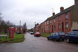
Astcote is a hamlet near Towcester in Northamptonshire, half a mile south of the little villages of Pattishall and Eastcote. Watling Street, the main Roman road from London to Chester, runs by the hamlet, having crossed the Great Ouse at Towcester.
The settlement is recorded in the Domesday Book under the name of Aviescote.[1]
Outside links
| ("Wikimedia Commons" has material about Astcote) |
References
- ↑ Astcote in the Domesday Book