Lockyer Island: Difference between revisions
Created page with "{{Infobox island |name=Lockyer Island |territory=BAT |picture= Lockyer Island.jpg |picture caption=Nordskjöld's photograph of Lockyer Island |map= |latitude=-64.4474 |longitu..." |
No edit summary |
||
| Line 4: | Line 4: | ||
|picture= Lockyer Island.jpg | |picture= Lockyer Island.jpg | ||
|picture caption=Nordskjöld's photograph of Lockyer Island | |picture caption=Nordskjöld's photograph of Lockyer Island | ||
|map= | |map=Lockyer Island, JRI Group, British Antarctic Territory.svg | ||
|latitude=-64.4474 | |latitude=-64.4474 | ||
|longitude=-57.5987 | |longitude=-57.5987 | ||
Latest revision as of 17:56, 6 January 2024
| Lockyer Island | |
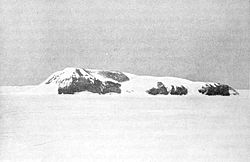
 Nordskjöld's photograph of Lockyer Island | |
|---|---|
| Location | |
| Location: | 64°26’51"S, 57°35’55"W |
| Highest point: | height= |
| Data | |
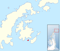
Lockyer Island lies in the south-west entrance of Admiralty Sound, between James Ross Island to the north and Snow Hill Island, amongst the James Ross Island Group, a group of islands lying off the north tip of Graham Land in the British Antarctic Territory.
Lockyer is two and a half miles long.
Exploration
The island was seen from a distance by James Ross on 7 January 1843, and called 'Cape Lockyer' after Captain Nicholas Lockyer (1782-1847), a friend of Captain F.R.M. Crozier, the officer commanding HMS Terror on Ross's expedition.
The feature was surveyed by the Swedish Antarctic Expedition under Otto Nordenskjöld on 9 March 1902, which proved the feature to be an island, and named 'Lockyer Island' in place of 'Cape'.
The island was further surveyed by the Falkland Islands Dependencies Survey from "Hope Bay" in September 1952.
Outside links
- Gazetteer and Map of The British Antarctic Territory: Lockyer Island
