Difference between revisions of "Thornton, North Riding"
From Wikishire
(Created page with "{{distinguish|Thornton-le-Beans}} {{Infobox town |name=Thornton |county=Yorkshire |riding=North |picture=Maltby Road, Thornton - geograph.org.uk - 2690775.jpg |picture caption...") |
(No difference)
|
Latest revision as of 18:02, 14 December 2023
- Not to be confused with Thornton-le-Beans
| Thornton | |
| Yorkshire North Riding | |
|---|---|
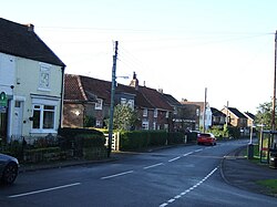
 Maltby Road, Thornton | |
| Location | |
| Grid reference: | NZ478135 |
| Location: | 54°30’54"N, 1°15’43"W |
| Data | |
| Post town: | Middlesbrough |
| Postcode: | TS8 |
| Local Government | |
| Council: | Middlesbrough |
Thornton is a village in the North Riding of Yorkshire, in the very north of the county, barely separated form the outer suburbs of Middlesbrough. Immediately to the north, separated by Stainton Beck, is Stainton, while the village's southern extent is curbed by the Maltby Beck.
This Yorkshire article is a stub: help to improve Wikishire by building it up.