Windmill Hill, Hampshire: Difference between revisions
Jump to navigation
Jump to search
Created page with "{{Infobox hill |name= Windmill Hill |county=Hampshire |range= |picture=Windmill Hill - geograph.org.uk - 844646.jpg |picture caption=Windmill Hill |os grid ref= SU715161 |lati..." |
No edit summary |
||
| Line 9: | Line 9: | ||
|longitude=-0.9825 | |longitude=-0.9825 | ||
|height=633 feet | |height=633 feet | ||
}} | }} | ||
'''Windmill Hill''' is a distinctive chalk hill in eastern [[Hampshire]], below whose western | '''Windmill Hill''' is a distinctive chalk hill in eastern [[Hampshire]], below whose western scarp runs the A3(M) road. It overlooks [[Chalton, Hampshire|Chalton]] to the east, and [[Clanfield, Hampshire|Clanfield]] to the west. | ||
The hill rises to 633 feet above sea level. It is named so because on its summit stands [[Chalton Windmill]], a Grade II listed building which lay derelict until the late 1970s, when it was restored and converted into a private residence.<ref name="Fowler1977">{{cite book|author=P. J. Fowler|title=Approaches to Archaeology|url=https://books.google.com/books?id=MGGvAAAAIAAJ|year=1977|publisher=A. and C. Black|isbn=978-0-7136-1747-4}}</ref> | The hill rises to 633 feet above sea level. It is named so because on its summit stands [[Chalton Windmill]], a Grade II listed building which lay derelict until the late 1970s, when it was restored and converted into a private residence.<ref name="Fowler1977">{{cite book|author=P. J. Fowler|title=Approaches to Archaeology|url=https://books.google.com/books?id=MGGvAAAAIAAJ|year=1977|publisher=A. and C. Black|isbn=978-0-7136-1747-4}}</ref> | ||
Latest revision as of 10:21, 10 January 2023
| Windmill Hill | |
| Hampshire | |
|---|---|
 Windmill Hill | |
| Summit: | 633 feet SU715161 50°56’24"N, -0°58’57"W |
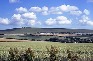
Windmill Hill is a distinctive chalk hill in eastern Hampshire, below whose western scarp runs the A3(M) road. It overlooks Chalton to the east, and Clanfield to the west.
The hill rises to 633 feet above sea level. It is named so because on its summit stands Chalton Windmill, a Grade II listed building which lay derelict until the late 1970s, when it was restored and converted into a private residence.[1]
On its northern slopes at Bascomb Copse sits Butser Ancient Farm, which moved there in 1991. The hill has numerous footpaths some of which lead to the small village of Blendworth and then to Horndean to the south, and Queen Elizabeth Country Park and Butser Hill, which is well within walking distance to the north.
References
- ↑ P. J. Fowler (1977). Approaches to Archaeology. A. and C. Black. ISBN 978-0-7136-1747-4. https://books.google.com/books?id=MGGvAAAAIAAJ.