Godthul: Difference between revisions
Jump to navigation
Jump to search
No edit summary |
No edit summary |
||
| Line 1: | Line 1: | ||
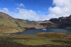
[[File:Godthul, South Georgia.jpg|right|thumb|300px|M/S ''Expedition'' at Godthul]] | [[File:Godthul, South Georgia.jpg|right|thumb|300px|M/S ''Expedition'' at Godthul]] | ||
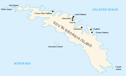
[[File: | [[File:South georgia Islands map-en.svg|right|thumb|250px|Settlements of South Georgia Island, showing Godthul]] | ||
'''Godthul''' is a bay on the north coast of [[South Georgia]], a mile long entered between [[Cape George]] and [[Long Point]]. It is found south of [[Cumberland Bay#Cumberland East Bay|Cumberland East Bay]] and north of [[Ocean Harbour]], at 54°17'S 36°18'W. | '''Godthul''' is a bay on the north coast of [[South Georgia]], a mile long entered between [[Cape George]] and [[Long Point]]. It is found south of [[Cumberland Bay#Cumberland East Bay|Cumberland East Bay]] and north of [[Ocean Harbour]], at 54°17'S 36°18'W. | ||
The name "Godthul" is Norwegian for "Good Hollow" and dates back to the period 1905–12. The name was apparently chosen by Norwegian sealers and whalers working in the area. | The name "Godthul" is Norwegian for "Good Hollow" and dates back to the period 1905–12. The name was apparently chosen by Norwegian sealers and whalers working in the area. | ||
Godthul was a whaling station which operated between 1908 and 1929. Godthul station was only a rudimentary land base, with main operations on a factory ship. It had an interruption between 1917 and | Godthul was a whaling station which operated between 1908 and 1929. Godthul station was only a rudimentary land base, with main operations on a factory ship. It had an interruption between 1917 and 1922, partly due to the First World War. | ||
==Location== | |||
*Location map: {{wmap|-54.2918|-36.294}} | |||
{{commons}} | {{commons}} | ||
==References== | |||
*{{basgaz}} | |||
[[Category:Bays of South Georgia]] | [[Category:Bays of South Georgia]] | ||
[[Category:Settlements of South Georgia and the South Sandwich Islands]] | [[Category:Settlements of South Georgia and the South Sandwich Islands]] | ||
Latest revision as of 17:21, 23 December 2022


Godthul is a bay on the north coast of South Georgia, a mile long entered between Cape George and Long Point. It is found south of Cumberland East Bay and north of Ocean Harbour, at 54°17'S 36°18'W.
The name "Godthul" is Norwegian for "Good Hollow" and dates back to the period 1905–12. The name was apparently chosen by Norwegian sealers and whalers working in the area.
Godthul was a whaling station which operated between 1908 and 1929. Godthul station was only a rudimentary land base, with main operations on a factory ship. It had an interruption between 1917 and 1922, partly due to the First World War.
Location
- Location map: 54°17’30"S, 36°17’38"W
| ("Wikimedia Commons" has material about Godthul) |
References
- Gazetteer and Map of the BAT and SGSSI: Godthul
