Renaud Island: Difference between revisions
Jump to navigation
Jump to search
No edit summary |
No edit summary |
||
| Line 6: | Line 6: | ||
|longitude=-66.0 | |longitude=-66.0 | ||
|group=Biscoe Islands | |group=Biscoe Islands | ||
|map=Renaud Island - Biscoe Islands, BAT.svg | |||
|highest height= | |highest height= | ||
|population=Uninhabited | |population=Uninhabited | ||
Latest revision as of 13:11, 4 December 2022
| Renaud Island | |
| Location | |
| Location: | -65.667 -66.0 |
| Data | |
| Population: | Uninhabited |
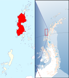
Renaud Island is an ice-covered island, lying between the Pitt Islands and Rabot Island amongst the Biscoe Islands, off the west coast of Graham Land in the British Antarctic Territory.
Renaud is 25 miles long and from four to ten miles wide. It is separated from Pitt Islands to the north-east by a narrow sound, and from Lavoisier Island to the southwest by Pendleton Strait.
Discovery
The island was first charted and named by the French Antarctic Expedition, 1908–10, under Jean-Baptiste Charcot.
References
- Gazetteer and Map of The British Antarctic Territory: Renaud Island

This British Antarctic Territory article is a stub: help to improve Wikishire by building it up.
