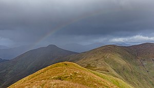
Luss Hills: Difference between revisions
Jump to navigation
Jump to search
Created page with "right|thumb|300px|Rainbow over the Luss Hills {{county|Dunbartonshire}} The '''Luss Hills''' are a range of..." |
No edit summary |
||
| Line 7: | Line 7: | ||
The hills are a short way north of [[Alexandria]] and [[Helensburgh]] and within easy reach of [[Glasgow]]. They are a popular destination for hillwalking | The hills are a short way north of [[Alexandria]] and [[Helensburgh]] and within easy reach of [[Glasgow]]. They are a popular destination for hillwalking | ||
The hills include:<ref>[http://www.clydesideimages.co.uk/hills--mountains-the-luss-hills.html Luss Hills]: Clydeside Images | The hills include:<ref>[http://www.clydesideimages.co.uk/hills--mountains-the-luss-hills.html Luss Hills]: Clydeside Images</ref> | ||
*[[Doune Hill]], the highest peak, at 2,408 feet | *[[Doune Hill]], the highest peak, at 2,408 feet | ||
Latest revision as of 14:12, 15 March 2022

The Luss Hills are a range of hills in Dunbartonshire, in the north-west of the county, in the tract caught between Loch Long in the west and Loch Lomond to the east. The hills are named after the village of Luss on the shore of Loch Lomond, and the Luss Water, a river running off the vills to the loch here.
The hills are within the Loch Lomond and the Trossachs National Park.
The hills are a short way north of Alexandria and Helensburgh and within easy reach of Glasgow. They are a popular destination for hillwalking
The hills include:[1]
- Doune Hill, the highest peak, at 2,408 feet
- Beinn Eich
- Beinn Dubh
- Mid Hill
Location
- Location map: 56°8’6"N, 4°45’12"W
References
- ↑ Luss Hills: Clydeside Images