Difference between revisions of "Aghada"
(Created page with "{{Infobox town |name=Aghada |irish=Áth Fhada |county=Cork |picture=Lower Aghada Pier - geograph.org.uk - 1385711.jpg |picture caption=Lower Aghada Pier |os grid ref=W855656 |...") |
(No difference)
|
Latest revision as of 22:48, 14 November 2021
| Aghada Irish: Áth Fhada | |
| County Cork | |
|---|---|
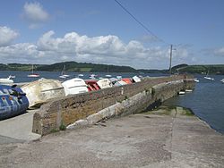
 Lower Aghada Pier | |
| Location | |
| Grid reference: | W855656 |
| Location: | 51°50’34"N, 8°12’40"W |
| Data | |
| Population: | 1,030 (2016) |
| Local Government | |
| Dáil constituency: |
Cork East |
Aghada is a village in County Cork. It is situated on the eastern side of Cork Harbour, seven miles south of Midleton.
Aghada is also the parish name for the area. Aghada parish consists of several small villages and townlands including Saleen, Scartleigh, Rostellan, Farsid, Upper Aghada, Lower Aghada, Whitegate, Guileen and Ballinrostig. There are several amenity sites in the area, including Rostellan Woods and Saleen Creek, as well as a number of beaches such as Inch Bay, White Bay, and Guileen Strand.
Aghada power station was originally built in the early 1980s and has since been expanded to become one of the largest power stations in the Republic of Ireland.[1]
Contents
Churches
- Presbyterian church in Upper Aghada.[2]
History
During First World War the Royal Munster Fusiliers (reserves) were garrisoned in Aghada, and there was a United States Naval Air Station in the area.[3] William Cosgrove, a First World War recipient of the Victoria Cross, is buried in Upper Aghada cemetery.[4]
Sport
- Aghada GAA club
References
- ↑ "New power station becomes Ireland's largest". Landmark Digital. 31 May 2010. http://www.breakingnews.ie/ireland/new-power-station-becomes-irelands-largest-459815.html.
- ↑ "Aghada Presbyterian Church". Dublin & Munster Presbytery. https://presbytery.ie/find-a-church/connacht-munster/aghada-presbyterian-church/.
- ↑ "United States Naval Air Service in Cork, Ireland". Cork Shipwrecks. http://www.corkshipwrecks.net/ooUnitedStatesNAS.html.
- ↑ "Aghada Old Cemetery - CO-AGDO-072 - Cosgrove". Historic Graves. http://historicgraves.com/aghada-old/co-agdo-072/grave.