Difference between revisions of "Charlestown, Dorset"
From Wikishire
(Created page with "{{Infobox town |name=Charlestown |county=Dorset |picture=Jetty on East Fleet, Dorset - geograph.org.uk - 448251.jpg |picture caption=Jetty on East Fleet by Charlestown |os gri...") |
(No difference)
|
Revision as of 21:15, 26 May 2021
| Charlestown | |
| Dorset | |
|---|---|
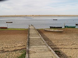
 Jetty on East Fleet by Charlestown | |
| Location | |
| Grid reference: | SY651792 |
| Location: | -2.494,/zoom=13 50.612, -2.494 |
| Data | |
| Local Government | |
| Council: | Dorset |
Charlestown is a suburb of Weymouth in Dorset, situated in the west of the town beside The Fleet, the closed water between the mainland and Chesil Beach. Charlestown is in the Chickerell parish.
The Hardy Way runs along the coast here.
Outside links
| ("Wikimedia Commons" has material about Charlestown, Dorset) |