Template:FP-River Corve: Difference between revisions
Jump to navigation
Jump to search
No edit summary |
No edit summary |
||
| Line 4: | Line 4: | ||
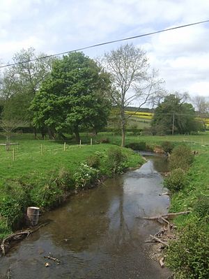
|text=The '''River Corve''' is a small river in [[Shropshire]], which ultimately is a tributary of the River Teme, which it joins in the town of Ludlow. The valley it flows through is known as the Corvedale, a term used as a general name for the area. | |text=The '''River Corve''' is a small river in [[Shropshire]], which ultimately is a tributary of the River Teme, which it joins in the town of Ludlow. The valley it flows through is known as the Corvedale, a term used as a general name for the area. | ||
Corvedale is the valley of the River Corve as it carves a green path between the soaring hills to either side; the dale is between Brown Clee Hill, Shropshire's highest hill to the south with its accompanying hills, and the long reach of Wenlock Edge to the north. It is said to be the southernmost 'dale' in Britain.}}<noinclude> | Corvedale is the valley of the River Corve as it carves a green path between the soaring hills to either side; the dale is between Brown Clee Hill, Shropshire's highest hill to the south with its accompanying hills, and the long reach of Wenlock Edge to the north. It is said to be the southernmost 'dale' in Britain.}}<noinclude>{{FP data}} | ||
Latest revision as of 09:27, 8 May 2021
 |
River CorveThe River Corve is a small river in Shropshire, which ultimately is a tributary of the River Teme, which it joins in the town of Ludlow. The valley it flows through is known as the Corvedale, a term used as a general name for the area. Corvedale is the valley of the River Corve as it carves a green path between the soaring hills to either side; the dale is between Brown Clee Hill, Shropshire's highest hill to the south with its accompanying hills, and the long reach of Wenlock Edge to the north. It is said to be the southernmost 'dale' in Britain. (Read more) |