Difference between revisions of "Rufford, Nottinghamshire"
From Wikishire
(Created page with "{{Infobox town |name=Rufford |county=Nottinghamshire |picture=Rufford Abbey (geograph 3674622).jpg |picture caption=Rufford Abbey |os grid ref=SK644647 |latitude=53.175 |longi...") |
(No difference)
|
Latest revision as of 20:47, 4 April 2021
| Rufford | |
| Nottinghamshire | |
|---|---|
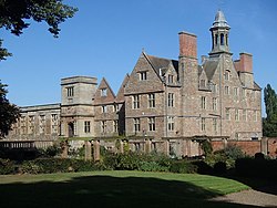
 Rufford Abbey | |
| Location | |
| Grid reference: | SK644647 |
| Location: | 53°10’30"N, 1°2’13"W |
| Data | |
| Post town: | Newark |
| Postcode: | NG22 |
| Dialling code: | 0115 |
| Local Government | |
| Council: | Newark and Sherwood |
| Parliamentary constituency: |
Sherwood |
Rufford, in Nottinghamshire, is the site of two villages whose inhabitants were evicted in the 12th century. Cistercian monasteries were established and the monks wished to ensure their isolation.
Much of the site of the villages is filled today by Rufford Country Park.