Dalton, Burton-in-Kendal: Difference between revisions
Jump to navigation
Jump to search
m Owain moved page Dalton, Westmorland to Dalton, Burton-in-Kendal |
No edit summary |
||
| Line 1: | Line 1: | ||
{{Infobox town | {{Infobox town | ||
|name=Dalton | |name=Dalton | ||
|county= | |county=Lancaster | ||
|picture=Russell Farm Enclosure, Dalton (geograph 4347926).jpg | |picture=Russell Farm Enclosure, Dalton (geograph 4347926).jpg | ||
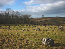
|picture caption=Russell Farm Enclosure, Dalton | |picture caption=Russell Farm Enclosure, Dalton | ||
| Line 15: | Line 15: | ||
|constituency=Westmorland and Lonsdale | |constituency=Westmorland and Lonsdale | ||
}} | }} | ||
'''Dalton''' is a hamlet in [[Westmorland]]. | '''Dalton''' is a hamlet in [[Lancashire]] that forms a township of the ancient parish of [[Burton-in-Kendal]], otherwise in [[Westmorland]]. | ||
Dalton is located about a mile east of [[Burton-in-Kendal]] and gives its name to Dalton Crags and [[Dalton Hall, | Dalton is located about a mile east of [[Burton-in-Kendal]] itself and gives its name to Dalton Crags and [[Dalton Hall, Lancashire|Dalton Hall]]. | ||
==Outside links== | ==Outside links== | ||
Latest revision as of 18:50, 5 December 2020
| Dalton | |
| Lancashire | |
|---|---|
 Russell Farm Enclosure, Dalton | |
| Location | |
| Grid reference: | SD542766 |
| Location: | 54°10’59"N, 2°42’4"W |
| Data | |
| Post town: | Carnforth |
| Postcode: | LA6 |
| Dialling code: | 01524 |
| Local Government | |
| Council: | Westmorland & Furness |
| Parliamentary constituency: |
Westmorland and Lonsdale |
Dalton is a hamlet in Lancashire that forms a township of the ancient parish of Burton-in-Kendal, otherwise in Westmorland.
Dalton is located about a mile east of Burton-in-Kendal itself and gives its name to Dalton Crags and Dalton Hall.
Outside links
| ("Wikimedia Commons" has material about Dalton, Burton-in-Kendal) |

This Lancashire article is a stub: help to improve Wikishire by building it up.
