Difference between revisions of "Symington, Midlothian"
From Wikishire
| Line 15: | Line 15: | ||
|constituency= | |constituency= | ||
}} | }} | ||
| − | '''Symington''' is a hamlet, of one farm and a few cottages, on the west side of the [[Gala Water]] amongst the [[Moorfoot Hills]] in southernmost [[Midlothian]]. It lies in the parish of [[Stow]] to the south of [[Fountainhall]]. | + | '''Symington''' is a hamlet, of one farm and a few cottages, on the west side of the [[Gala Water]] amongst the [[Moorfoot Hills]] in southernmost [[Midlothian]]. It lies in the parish of [[Stow, Midlothian|Stow]] to the south of [[Fountainhall]]. |
The railway line from [[Galashiels]] northwards to [[Edinburgh]] runs up the dale of the Gala past Symington, although there was never a station here, with the nearest being at Fountainhall, now closed. | The railway line from [[Galashiels]] northwards to [[Edinburgh]] runs up the dale of the Gala past Symington, although there was never a station here, with the nearest being at Fountainhall, now closed. | ||
{{stub}} | {{stub}} | ||
Latest revision as of 15:41, 1 November 2020
| Symington | |
| Midlothian | |
|---|---|
 Symington Mains | |
| Location | |
| Grid reference: | NT436481 |
| Location: | 55°43’25"N, 2°53’55"W |
| Data | |
| Post town: | Galashiels |
| Postcode: | TD1 |
| Local Government | |
| Council: | Scottish Borders |
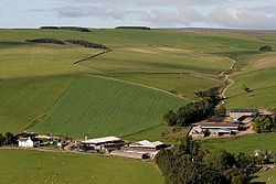
Symington is a hamlet, of one farm and a few cottages, on the west side of the Gala Water amongst the Moorfoot Hills in southernmost Midlothian. It lies in the parish of Stow to the south of Fountainhall.
The railway line from Galashiels northwards to Edinburgh runs up the dale of the Gala past Symington, although there was never a station here, with the nearest being at Fountainhall, now closed.
This Midlothian article is a stub: help to improve Wikishire by building it up.