Charborough: Difference between revisions
Created page with "{{Infobox town |name=Charborough |county=Dorset |picture=Charborough Park, estate chapel - geograph.org.uk - 456591.jpg |picture caption=St Mary's Church, Charborough |os grid..." |
(No difference)
|
Latest revision as of 23:03, 20 May 2020
| Charborough | |
| Dorset | |
|---|---|
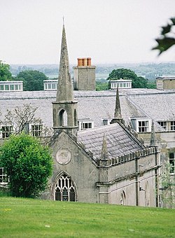
 St Mary's Church, Charborough | |
| Location | |
| Grid reference: | SY925978 |
| Location: | 50°46’50"N, 2°6’24"W |
| Data | |
| Local Government | |
| Council: | Dorset |
Charborough is an historic former parish and manor in south-eastern Dorset which survives today as a hamlet. Charborough stands beside an affluent of the River Stour, six miles west of Wimborne Minster,[1] and is today part of the parish of Morden.
The surviving former parish church is dedicated to St Mary.[2]
The centrepiece of the hamlet is the manor house; Charborough House.
St Mary's Church
The mediæval church of the former parish of Charborough stood immediately south-west of the manor house (in its latest form Charborough House). The mediæval church was demolished and rebuilt on the same site in 1775 in the Gothic Revival style,[3] by Thomas Erle Drax, and dedicated to St Mary, and was remodelled in 1837 by John Sawbridge Erle-Drax who in 1826 had married the heiress Sarah Frances Erle-Drax of Charborough,[4] and had assumed her surname and arms.
The church faces almost due east, as is usual, whilst the front façade of the house faces north-east. It is a Grade II* listed building, but the listing relates only to its furnishings.[2] Today it serves as a mausoleum and burial place for the Drax family, the functioning parish church being at Morden.
Above the door of a small arched building nearby is an inscription, dated 1686, commemorating the meeting of the "Patriotic individuals who concerted the plan of the Revolution in 1688".
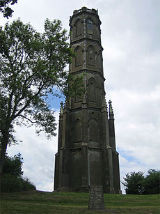
Charborough Tower

Charborough Tower is a Grade II* listed octagonal folly tower dating from 1790, extended in 1839 into a five-storey building. It stands on a hill south-east of the house (50°46’39"N, 2°6’6"W)[5] with the vista of a triumphal way running between them.[6]
Charborough with its tower is the model for "Welland House" in the novel Two on a Tower by Thomas Hardy.[7]
References
- ↑ Wilson, John M., Imperial Gazetteer of England and Wales, London, 1870
- ↑ 2.0 2.1 National Heritage List 1120553: Parish Church of Saint Mary, Charborough
- ↑ Listed building text
- ↑ www.historyofparliamentonline.org
- ↑ National Heritage List 1120555: Charborough Tower
- ↑ Nikolaus Pevsner: The Buildings of England: Dorset, 1972 Penguin Books ISBN 978-0-300-09598-2pages 139–141
- ↑ Letter from Hardy to Bertram Windle, transcribed by Birgit Plietzsch