Caundle Marsh: Difference between revisions
Jump to navigation
Jump to search
Created page with "{{Infobox town |name=Caundle Marsh |county=Dorset |picture=Tut Hill Farmhouse - geograph.org.uk - 420867.jpg |picture caption=Tut Hill Farm, Caundle Marsh |os grid ref=ST67813..." |
(No difference)
|
Latest revision as of 20:31, 20 May 2020
| Caundle Marsh | |
| Dorset | |
|---|---|
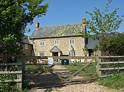
 Tut Hill Farm, Caundle Marsh | |
| Location | |
| Grid reference: | ST678133 |
| Location: | 50°55’8"N, 2°27’40"W |
| Data | |
| Population: | 70 (est.) |
| Post town: | Sherborne |
| Postcode: | DT9 |
| Local Government | |
| Council: | Dorset |
| Parliamentary constituency: |
West Dorset |
Caundle Marsh is a hamlet in north-western Dorset, situated in the Blackmore Vale, four miles south-east of Sherborne (and within the Sherborne Hundred).
The parish church of St Peter and St Paul was completed in 1857.[1]
Outside links
| ("Wikimedia Commons" has material about Marsh Caundle Marsh) |
References
- ↑ The Buildings of England: Dorset, by John Newman and Nikolaus Pevsner, Yale University Press, 1972. 554 pages.
