Burton, Hampshire: Difference between revisions
| Line 55: | Line 55: | ||
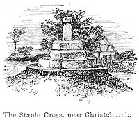
The parish also contains a Scheduled Ancient Monument, Staple Cross. Very little is known about the truncated stone obelisk that stands at the southern extremity of the village but one suggestion is that it was a boundary marker between the tithings of Christchurch and Burton.<ref name=b13/> Another source states that the 'cross' at Staple Cross, was knocked over by a Sherman tank during the Second World War, hence the somewhat stunted remains, but analysis of the engraving of 1863 would suggest that this is little more than folklore.<ref>Wise, John R.: '[The New Forest: Its History and Its Scenery]' (1863) page 288</ref> | The parish also contains a Scheduled Ancient Monument, Staple Cross. Very little is known about the truncated stone obelisk that stands at the southern extremity of the village but one suggestion is that it was a boundary marker between the tithings of Christchurch and Burton.<ref name=b13/> Another source states that the 'cross' at Staple Cross, was knocked over by a Sherman tank during the Second World War, hence the somewhat stunted remains, but analysis of the engraving of 1863 would suggest that this is little more than folklore.<ref>Wise, John R.: '[The New Forest: Its History and Its Scenery]' (1863) page 288</ref> | ||
[[File:The New Forest its history and its scenery - page 288. | [[File:The New Forest its history and its scenery - page 288.jpg|right|thumb|200px|Engraving of the Staple Cross]] | ||
==Outside links== | ==Outside links== | ||
Latest revision as of 20:00, 19 May 2020
| Burton | |
| Hampshire | |
|---|---|
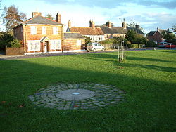
 Burton Green looking east towards Salisbury Road | |
| Location | |
| Grid reference: | SZ166947 |
| Location: | 50°45’9"N, 1°45’54"W |
| Data | |
| Post town: | Christchurch |
| Postcode: | BH23 |
| Local Government | |
| Council: | Bournemouth, Christchurch and Poole |
| Parliamentary constituency: |
Christchurch |
Burton is a village in south-western Hampshire, to the north of Christchurch, separated from the town by the sweep of the A35 and a narrow belt of farmland and utility land. The parish is elevated above the Avon Valley on a gravel plateau and includes the village of Burton, plus the hamlets of Winkton, Bockhampton and Holfleet.
The name 'Burton' is Anglo-Saxon but it first appears in the record in the twelfth-century.
The oldest existing parts of the village date back to the early 18th century. It was greatly expanded in the 1970s, today the population is around 4,000, in an expanded village which extends southward to within three-quarters of a mile of the Christchurch urban area.
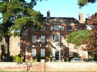
By the village stands Burton Hall, a large 18th-century residence which is Grade II* listed.
Geography
The village stands on a gravel terrace above the flood plain of the Avon Valley. It is a linear settlement along the historic route from Christchurch to Ringwood and Salisbury.[1] To the west, the Avon Valley is designated a Special Protection Area (SPA), Ramsar site and Site of Special Scientific Interest.
The area is drained by a small stream, known as the Clockhouse Stream, which meanders through the northern end of the village and across the flood plain, before joining the Avon near Christchurch town centre.
The Avon Valley Path, a 34-mile trail from Christchurch to Salisbury, passes through the village.
Churches
- Church of England: St Luke's
- United Reformed Church: Burton URC
St Luke's Church was built in 1874-75 and designed by Benjamin Ferrey.[2]
The church is built in the Early English Gothic style, from red brick with stone dressings. The slate roof leads to a stone coped gable end with bellcote.
History
There is archaeological evidence that Palaeolithic and Neolithic people occupied the lower part of the Avon Valley but the first evidence of permanent residence at Burton dates back to the Mesolithic.[1] It is thought that the obstacle of the flood plain led to the development of an alternative route north on which fringe settlements like Burton and Winkton grew.
Burton is not recorded in the Domesday Book. The earliest mention of the name occurs in the twelfth century but it is likely that prior to this, official records included it as part of the lands of Twynham or Christchurch as it was later known. The village's name is from the Old English language, presumably from gebur, so as to mean 'farm estate'.[1]
The oldest buildings in the village date back to at least the early 18th century. John Marius Wilson's Imperial Gazetteer of England and Wales, published 1870-1872, records the then population of Burton as 582.[3]
Burton was greatly expanded in the 1970s and 1980s and today there are more than 1,700 dwellings and a population of nearly 4,000.[4][5]
Winkton is the second largest settlement in the parish with a population of about 180.
About the village

Burton Hall is a large 18th-century gentleman's residence which is a Grade II* listed building.[1] The house has since been divided into flats but the interior still retains its large staircase, moulded architrave, six-panelled doors and 18th-century fireplaces.
Another listed building is Whitehayes House (also known as 'Sunnyhayes' and 'Westhayes'),[6] standing just off Burton Green, where Admiral Edmund Lyons was born.
The parish also contains a Scheduled Ancient Monument, Staple Cross. Very little is known about the truncated stone obelisk that stands at the southern extremity of the village but one suggestion is that it was a boundary marker between the tithings of Christchurch and Burton.[1] Another source states that the 'cross' at Staple Cross, was knocked over by a Sherman tank during the Second World War, hence the somewhat stunted remains, but analysis of the engraving of 1863 would suggest that this is little more than folklore.[7]

Outside links
| ("Wikimedia Commons" has material about Christchurch Burton, Hampshire) |
References
- ↑ 1.0 1.1 1.2 1.3 1.4 Burton conservation area appraisal and management plan (2007) pp.13-14
- ↑ National Heritage List 1154270: Parish Church of St Luke
- ↑ "A Vision of Britain Through Time". http://www.visionofbritain.org.uk/place/23287.
- ↑ Dorset For You - Burton (2010)
- ↑ The State of Christchurch: A Profile of Christchurch and Its Residents (5th Edition) p.32
- ↑ National Heritage List 1154338: Sunnyhayes
- ↑ Wise, John R.: '[The New Forest: Its History and Its Scenery]' (1863) page 288
- Moxey, Sarah (1997). Avon Valley Footpath Guide. Halsgrove. p. 79. ISBN 978-1-874448-26-6.
